You are here: Home > Network List > UW - Pacific Northwest Regional Seismic Network Stations List
> Station CVILL Solar Farm Field, Colville, WA, USA > Earthquake Result Viewer
CVILL Solar Farm Field, Colville, WA, USA - Earthquake Result Viewer
| Earthquake location: |
Southeast Of Honshu, Japan |
| Earthquake latitude/longitude: |
30.0/139.9 |
| Earthquake time(UTC): |
2023/10/05 (278) 01:59:58 GMT |
| Earthquake Depth: |
10 km |
| Earthquake Magnitude: |
6.1 mww |
| Earthquake Catalog/Contributor: |
NEIC PDE/us |
|
| Network: |
UW Pacific Northwest Regional Seismic Network |
| Station: |
CVILL Solar Farm Field, Colville, WA, USA |
| Lat/Lon: |
48.55 N/117.87 W |
| Elevation: |
581 m |
|
| Distance: |
75.5 deg |
| Az: |
42.121 deg |
| Baz: |
298.831 deg |
| Ray Param: |
0.051607728 |
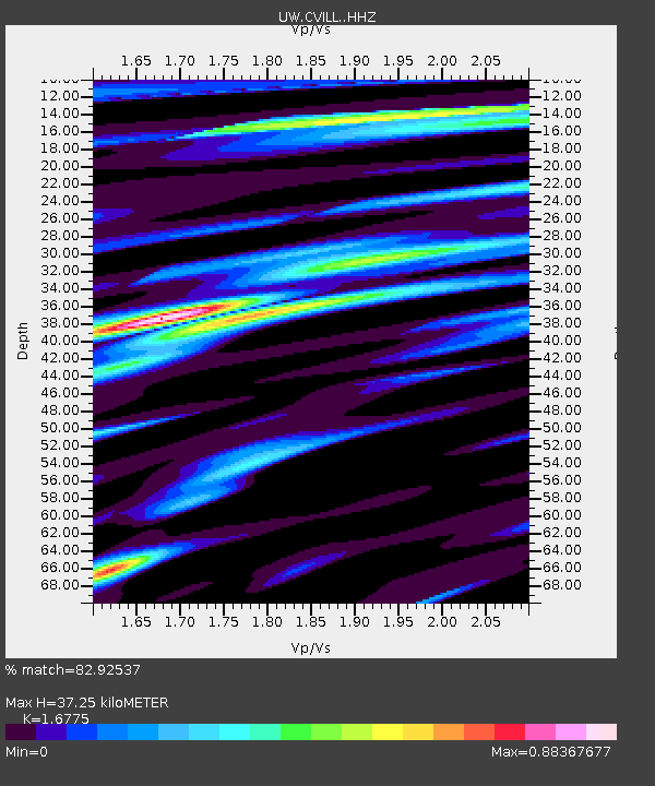
| Estimated Moho Depth: |
37.25 km |
| Estimated Crust Vp/Vs: |
1.68 |
| Assumed Crust Vp: |
6.571 km/s |
| Estimated Crust Vs: |
3.917 km/s |
| Estimated Crust Poisson's Ratio: |
0.22 |
|
| Radial Match: |
82.92537 % |
| Radial Bump: |
400 |
| Transverse Match: |
65.34055 % |
| Transverse Bump: |
400 |
| SOD ConfigId: |
31937991 |
| Insert Time: |
2023-10-19 02:33:44.281 +0000 |
| GWidth: |
2.5 |
| Max Bumps: |
400 |
| Tol: |
0.001 |
|

Signal To Noise
| Channel | StoN | STA | LTA |
| UW:CVILL: :HHZ:20231005T02:11:12.189972Z | 7.70344 | 7.978344E-7 | 1.0356858E-7 |
| UW:CVILL: :HHN:20231005T02:11:12.189972Z | 1.635288 | 1.8634024E-7 | 1.13949504E-7 |
| UW:CVILL: :HHE:20231005T02:11:12.189972Z | 2.597057 | 2.6770817E-7 | 1.03081355E-7 |
| Arrivals |
| Ps | 4.0 SECOND |
| PpPs | 15 SECOND |
| PsPs/PpSs | 19 SECOND |


