You are here: Home > Network List > UW - Pacific Northwest Regional Seismic Network Stations List
> Station RPW2 RPW2, Rockport WA > Earthquake Result Viewer
RPW2 RPW2, Rockport WA - Earthquake Result Viewer
| Earthquake location: |
Southeast Of Honshu, Japan |
| Earthquake latitude/longitude: |
30.0/139.9 |
| Earthquake time(UTC): |
2023/10/05 (278) 01:59:58 GMT |
| Earthquake Depth: |
10 km |
| Earthquake Magnitude: |
6.1 mww |
| Earthquake Catalog/Contributor: |
NEIC PDE/us |
|
| Network: |
UW Pacific Northwest Regional Seismic Network |
| Station: |
RPW2 RPW2, Rockport WA |
| Lat/Lon: |
48.44 N/121.53 W |
| Elevation: |
694 m |
|
| Distance: |
73.4 deg |
| Az: |
43.391 deg |
| Baz: |
296.442 deg |
| Ray Param: |
0.05300667 |
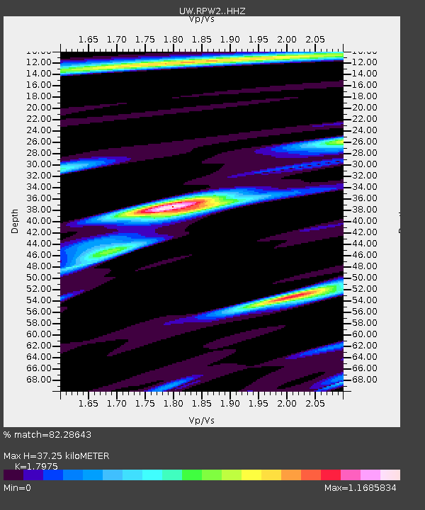
| Estimated Moho Depth: |
37.25 km |
| Estimated Crust Vp/Vs: |
1.80 |
| Assumed Crust Vp: |
6.566 km/s |
| Estimated Crust Vs: |
3.653 km/s |
| Estimated Crust Poisson's Ratio: |
0.28 |
|
| Radial Match: |
82.28643 % |
| Radial Bump: |
400 |
| Transverse Match: |
73.702644 % |
| Transverse Bump: |
400 |
| SOD ConfigId: |
31937991 |
| Insert Time: |
2023-10-19 02:35:40.938 +0000 |
| GWidth: |
2.5 |
| Max Bumps: |
400 |
| Tol: |
0.001 |
|

Signal To Noise
| Channel | StoN | STA | LTA |
| UW:RPW2: :HHZ:20231005T02:11:00.009979Z | 3.4103694 | 6.878043E-7 | 2.016803E-7 |
| UW:RPW2: :HHN:20231005T02:11:00.009979Z | 2.008228 | 2.3224761E-7 | 1.1564802E-7 |
| UW:RPW2: :HHE:20231005T02:11:00.009979Z | 1.3787097 | 2.5058335E-7 | 1.8175209E-7 |
| Arrivals |
| Ps | 4.7 SECOND |
| PpPs | 15 SECOND |
| PsPs/PpSs | 20 SECOND |


