You are here: Home > Network List > G - GEOSCOPE Stations List
> Station INU Inuyama, Japan > Earthquake Result Viewer
INU Inuyama, Japan - Earthquake Result Viewer
| Earthquake location: |
Mindanao, Philippines |
| Earthquake latitude/longitude: |
6.7/123.4 |
| Earthquake time(UTC): |
2010/07/23 (204) 22:08:11 GMT |
| Earthquake Depth: |
607 km |
| Earthquake Magnitude: |
6.3 MB, 7.3 MW, 7.3 MW |
| Earthquake Catalog/Contributor: |
WHDF/NEIC |
|
| Network: |
G GEOSCOPE |
| Station: |
INU Inuyama, Japan |
| Lat/Lon: |
35.35 N/137.03 E |
| Elevation: |
132 m |
|
| Distance: |
31.1 deg |
| Az: |
21.863 deg |
| Baz: |
206.901 deg |
| Ray Param: |
0.076360166 |
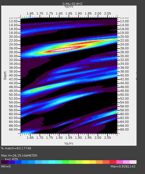
| Estimated Moho Depth: |
26.25 km |
| Estimated Crust Vp/Vs: |
1.83 |
| Assumed Crust Vp: |
6.461 km/s |
| Estimated Crust Vs: |
3.541 km/s |
| Estimated Crust Poisson's Ratio: |
0.29 |
|
| Radial Match: |
93.17748 % |
| Radial Bump: |
338 |
| Transverse Match: |
81.471924 % |
| Transverse Bump: |
400 |
| SOD ConfigId: |
319893 |
| Insert Time: |
2011-01-05 09:58:24.076 +0000 |
| GWidth: |
2.5 |
| Max Bumps: |
400 |
| Tol: |
0.001 |
|
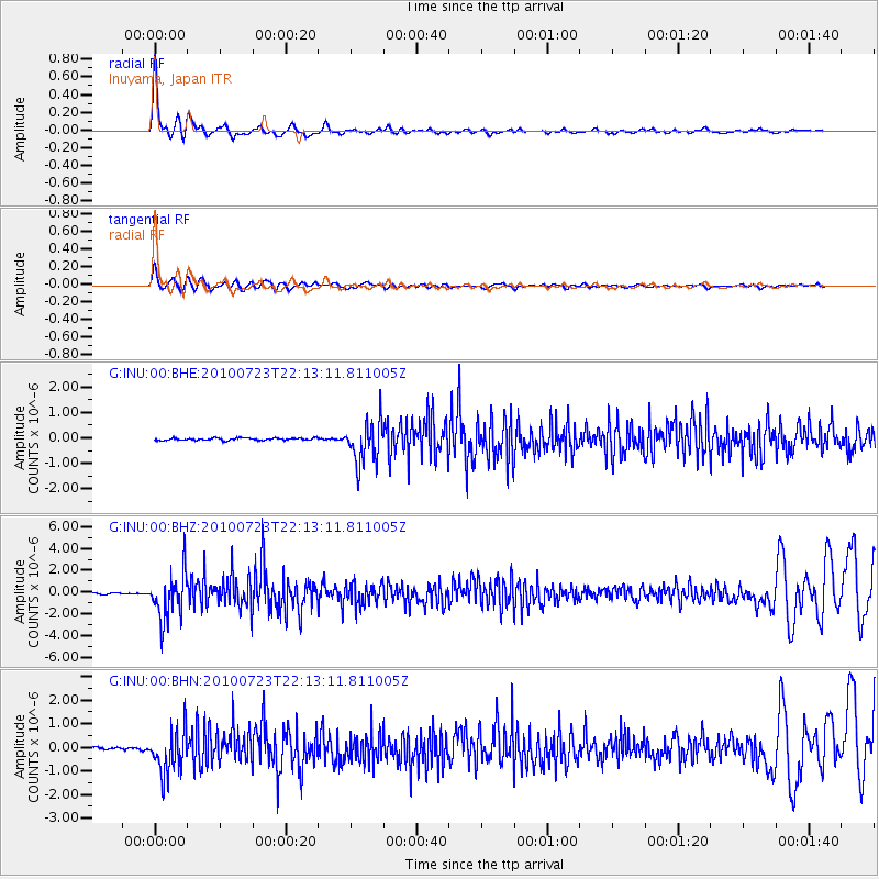
Signal To Noise
| Channel | StoN | STA | LTA |
| G:INU:00:BHZ:20100723T22:13:11.811005Z | 24.150383 | 2.1502815E-6 | 8.903716E-8 |
| G:INU:00:BHN:20100723T22:13:11.811005Z | 16.202845 | 9.491875E-7 | 5.8581538E-8 |
| G:INU:00:BHE:20100723T22:13:11.811005Z | 18.183344 | 8.3915586E-7 | 4.61497E-8 |
| Arrivals |
| Ps | 3.6 SECOND |
| PpPs | 11 SECOND |
| PsPs/PpSs | 14 SECOND |


