You are here: Home > Network List > GE - GEOFON Stations List
> Station EIL GEOFON Station Eilat, Israel > Earthquake Result Viewer
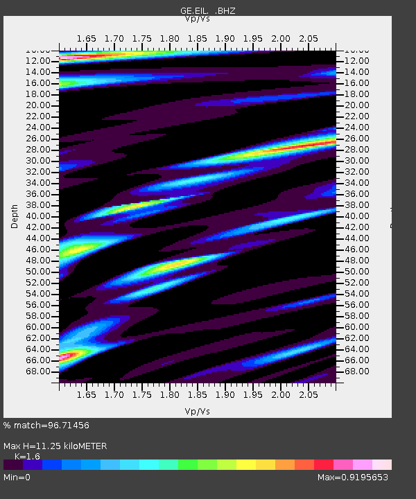
EIL GEOFON Station Eilat, Israel - Earthquake Result Viewer
| Earthquake location: |
Mindanao, Philippines |
| Earthquake latitude/longitude: |
6.7/123.4 |
| Earthquake time(UTC): |
2010/07/23 (204) 22:08:11 GMT |
| Earthquake Depth: |
607 km |
| Earthquake Magnitude: |
6.3 MB, 7.3 MW, 7.3 MW |
| Earthquake Catalog/Contributor: |
WHDF/NEIC |
|
| Network: |
GE GEOFON |
| Station: |
EIL GEOFON Station Eilat, Israel |
| Lat/Lon: |
29.67 N/34.95 E |
| Elevation: |
210 m |
|
| Distance: |
85.4 deg |
| Az: |
299.21 deg |
| Baz: |
84.936 deg |
| Ray Param: |
0.043028124 |
| Estimated Moho Depth: |
11.25 km |
| Estimated Crust Vp/Vs: |
1.60 |
| Assumed Crust Vp: |
6.472 km/s |
| Estimated Crust Vs: |
4.045 km/s |
| Estimated Crust Poisson's Ratio: |
0.18 |
|
| Radial Match: |
96.71456 % |
| Radial Bump: |
400 |
| Transverse Match: |
94.352455 % |
| Transverse Bump: |
400 |
| SOD ConfigId: |
319893 |
| Insert Time: |
2011-01-05 09:59:28.448 +0000 |
| GWidth: |
2.5 |
| Max Bumps: |
400 |
| Tol: |
0.001 |
|

Signal To Noise
| Channel | StoN | STA | LTA |
| GE:EIL: :BHZ:20100723T22:19:14.400024Z | 53.556606 | 6.309275E-6 | 1.17805726E-7 |
| GE:EIL: :BHN:20100723T22:19:14.400024Z | 2.6676023 | 2.4496038E-7 | 9.182792E-8 |
| GE:EIL: :BHE:20100723T22:19:14.400024Z | 20.089005 | 1.4774165E-6 | 7.354354E-8 |
| Arrivals |
| Ps | 1.1 SECOND |
| PpPs | 4.4 SECOND |
| PsPs/PpSs | 5.5 SECOND |


