You are here: Home > Network List > AU - Australian Seismological Centre Stations List
> Station GIRL Giralia, Western Australia > Earthquake Result Viewer
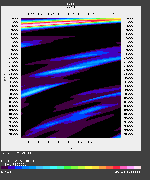
GIRL Giralia, Western Australia - Earthquake Result Viewer
| Earthquake location: |
Mindanao, Philippines |
| Earthquake latitude/longitude: |
6.5/123.5 |
| Earthquake time(UTC): |
2010/07/23 (204) 22:51:12 GMT |
| Earthquake Depth: |
586 km |
| Earthquake Magnitude: |
6.9 MB, 7.6 MW, 7.6 MW |
| Earthquake Catalog/Contributor: |
WHDF/NEIC |
|
| Network: |
AU Australian Seismological Centre |
| Station: |
GIRL Giralia, Western Australia |
| Lat/Lon: |
22.64 S/114.23 E |
| Elevation: |
111 m |
|
| Distance: |
30.3 deg |
| Az: |
197.071 deg |
| Baz: |
18.406 deg |
| Ray Param: |
0.07692429 |
| Estimated Moho Depth: |
12.75 km |
| Estimated Crust Vp/Vs: |
1.73 |
| Assumed Crust Vp: |
6.285 km/s |
| Estimated Crust Vs: |
3.628 km/s |
| Estimated Crust Poisson's Ratio: |
0.25 |
|
| Radial Match: |
91.08188 % |
| Radial Bump: |
359 |
| Transverse Match: |
89.74671 % |
| Transverse Bump: |
400 |
| SOD ConfigId: |
319893 |
| Insert Time: |
2011-01-05 10:17:16.854 +0000 |
| GWidth: |
2.5 |
| Max Bumps: |
400 |
| Tol: |
0.001 |
|

Signal To Noise
| Channel | StoN | STA | LTA |
| AU:GIRL: :BHZ:20100723T22:56:07.270007Z | 4.4198675 | 1.058482E-5 | 2.3948273E-6 |
| AU:GIRL: :BHN:20100723T22:56:07.270007Z | 3.0135503 | 9.179009E-6 | 3.045912E-6 |
| AU:GIRL: :BHE:20100723T22:56:07.270007Z | 1.9597251 | 7.0277247E-6 | 3.5860767E-6 |
| Arrivals |
| Ps | 1.6 SECOND |
| PpPs | 5.2 SECOND |
| PsPs/PpSs | 6.7 SECOND |


