You are here: Home > Network List > AU - Australian Seismological Centre Stations List
> Station KMBL Kambalda, Western Australia > Earthquake Result Viewer
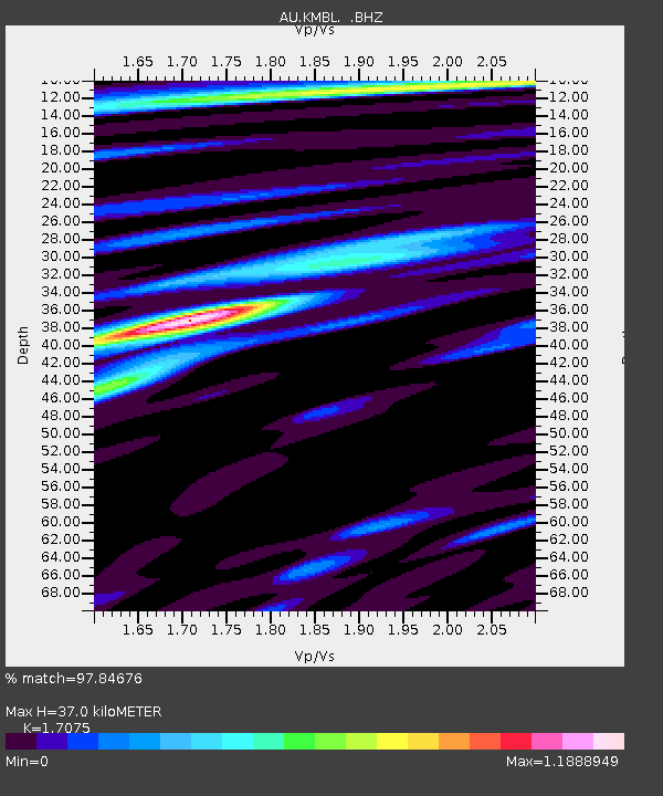
KMBL Kambalda, Western Australia - Earthquake Result Viewer
| Earthquake location: |
Mindanao, Philippines |
| Earthquake latitude/longitude: |
6.5/123.5 |
| Earthquake time(UTC): |
2010/07/23 (204) 22:51:12 GMT |
| Earthquake Depth: |
586 km |
| Earthquake Magnitude: |
6.9 MB, 7.6 MW, 7.6 MW |
| Earthquake Catalog/Contributor: |
WHDF/NEIC |
|
| Network: |
AU Australian Seismological Centre |
| Station: |
KMBL Kambalda, Western Australia |
| Lat/Lon: |
31.37 S/121.88 E |
| Elevation: |
370 m |
|
| Distance: |
37.7 deg |
| Az: |
182.219 deg |
| Baz: |
2.578 deg |
| Ray Param: |
0.072998434 |
| Estimated Moho Depth: |
37.0 km |
| Estimated Crust Vp/Vs: |
1.71 |
| Assumed Crust Vp: |
6.459 km/s |
| Estimated Crust Vs: |
3.783 km/s |
| Estimated Crust Poisson's Ratio: |
0.24 |
|
| Radial Match: |
97.84676 % |
| Radial Bump: |
343 |
| Transverse Match: |
85.40982 % |
| Transverse Bump: |
400 |
| SOD ConfigId: |
319893 |
| Insert Time: |
2011-01-05 10:17:52.448 +0000 |
| GWidth: |
2.5 |
| Max Bumps: |
400 |
| Tol: |
0.001 |
|

Signal To Noise
| Channel | StoN | STA | LTA |
| AU:KMBL: :BHZ:20100723T22:57:08.444995Z | 6.974164 | 7.834674E-6 | 1.1233853E-6 |
| AU:KMBL: :BHN:20100723T22:57:08.444995Z | 5.417703 | 4.52018E-6 | 8.3433514E-7 |
| AU:KMBL: :BHE:20100723T22:57:08.444995Z | 2.0328765 | 1.2591943E-6 | 6.1941506E-7 |
| Arrivals |
| Ps | 4.3 SECOND |
| PpPs | 14 SECOND |
| PsPs/PpSs | 19 SECOND |


