You are here: Home > Network List > AU - Australian Seismological Centre Stations List
> Station CTA Charters Towers, Queensland > Earthquake Result Viewer
CTA Charters Towers, Queensland - Earthquake Result Viewer
| Earthquake location: |
Mindanao, Philippines |
| Earthquake latitude/longitude: |
6.5/123.5 |
| Earthquake time(UTC): |
2010/07/23 (204) 22:51:12 GMT |
| Earthquake Depth: |
586 km |
| Earthquake Magnitude: |
6.9 MB, 7.6 MW, 7.6 MW |
| Earthquake Catalog/Contributor: |
WHDF/NEIC |
|
| Network: |
AU Australian Seismological Centre |
| Station: |
CTA Charters Towers, Queensland |
| Lat/Lon: |
20.09 S/146.25 E |
| Elevation: |
426 m |
|
| Distance: |
34.6 deg |
| Az: |
140.178 deg |
| Baz: |
317.387 deg |
| Ray Param: |
0.07468552 |
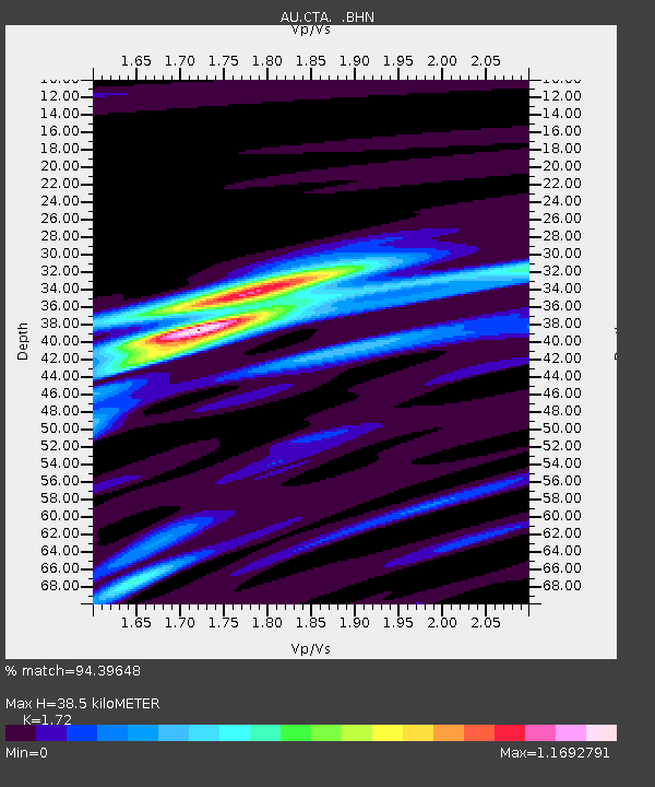
| Estimated Moho Depth: |
38.5 km |
| Estimated Crust Vp/Vs: |
1.72 |
| Assumed Crust Vp: |
6.522 km/s |
| Estimated Crust Vs: |
3.792 km/s |
| Estimated Crust Poisson's Ratio: |
0.24 |
|
| Radial Match: |
94.39648 % |
| Radial Bump: |
209 |
| Transverse Match: |
77.72767 % |
| Transverse Bump: |
400 |
| SOD ConfigId: |
319893 |
| Insert Time: |
2011-01-05 10:17:52.654 +0000 |
| GWidth: |
2.5 |
| Max Bumps: |
400 |
| Tol: |
0.001 |
|

Signal To Noise
| Channel | StoN | STA | LTA |
| AU:CTA: :BHZ:20100723T22:56:43.550006Z | 19.190382 | 2.125854E-5 | 1.1077707E-6 |
| AU:CTA: :BHN:20100723T22:56:43.550006Z | 10.483168 | 1.0962682E-5 | 1.0457413E-6 |
| AU:CTA: :BHE:20100723T22:56:43.550006Z | 8.292017 | 1.03928305E-5 | 1.2533538E-6 |
| Arrivals |
| Ps | 4.6 SECOND |
| PpPs | 15 SECOND |
| PsPs/PpSs | 19 SECOND |


