You are here: Home > Network List > C0 - Colorado Geological Survey Seismic Network Stations List
> Station N23A Red Feather Lakes, CO > Earthquake Result Viewer
N23A Red Feather Lakes, CO - Earthquake Result Viewer
| Earthquake location: |
Southeast Of Honshu, Japan |
| Earthquake latitude/longitude: |
30.0/140.0 |
| Earthquake time(UTC): |
2023/10/06 (279) 01:31:17 GMT |
| Earthquake Depth: |
10 km |
| Earthquake Magnitude: |
6.1 mww |
| Earthquake Catalog/Contributor: |
NEIC PDE/us |
|
| Network: |
C0 Colorado Geological Survey Seismic Network |
| Station: |
N23A Red Feather Lakes, CO |
| Lat/Lon: |
40.89 N/105.94 W |
| Elevation: |
2452 m |
|
| Distance: |
86.7 deg |
| Az: |
43.899 deg |
| Baz: |
307.524 deg |
| Ray Param: |
0.04383933 |
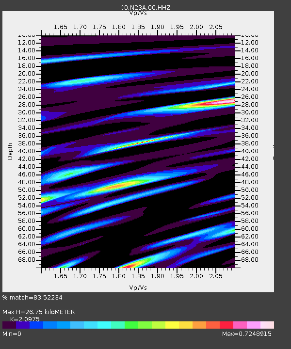
| Estimated Moho Depth: |
26.75 km |
| Estimated Crust Vp/Vs: |
2.10 |
| Assumed Crust Vp: |
6.306 km/s |
| Estimated Crust Vs: |
3.006 km/s |
| Estimated Crust Poisson's Ratio: |
0.35 |
|
| Radial Match: |
83.52234 % |
| Radial Bump: |
400 |
| Transverse Match: |
82.32741 % |
| Transverse Bump: |
400 |
| SOD ConfigId: |
31937991 |
| Insert Time: |
2023-10-20 01:39:25.979 +0000 |
| GWidth: |
2.5 |
| Max Bumps: |
400 |
| Tol: |
0.001 |
|

Signal To Noise
| Channel | StoN | STA | LTA |
| C0:N23A:00:HHZ:20231006T01:43:29.809025Z | 3.2486277 | 2.849088E-7 | 8.7701274E-8 |
| C0:N23A:00:HHN:20231006T01:43:29.809025Z | 0.4743094 | 4.6291415E-8 | 9.759751E-8 |
| C0:N23A:00:HHE:20231006T01:43:29.809025Z | 0.9482738 | 7.901287E-8 | 8.3322846E-8 |
| Arrivals |
| Ps | 4.7 SECOND |
| PpPs | 13 SECOND |
| PsPs/PpSs | 18 SECOND |


