You are here: Home > Network List > MB - Montana Regional Seismic Network Stations List
> Station FCMT Ford Creek > Earthquake Result Viewer
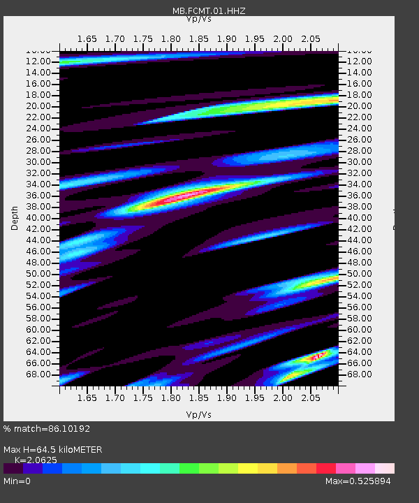
FCMT Ford Creek - Earthquake Result Viewer
| Earthquake location: |
Southeast Of Honshu, Japan |
| Earthquake latitude/longitude: |
30.0/140.0 |
| Earthquake time(UTC): |
2023/10/06 (279) 01:31:17 GMT |
| Earthquake Depth: |
10 km |
| Earthquake Magnitude: |
6.1 mww |
| Earthquake Catalog/Contributor: |
NEIC PDE/us |
|
| Network: |
MB Montana Regional Seismic Network |
| Station: |
FCMT Ford Creek |
| Lat/Lon: |
46.46 N/110.86 W |
| Elevation: |
1836 m |
|
| Distance: |
80.6 deg |
| Az: |
41.45 deg |
| Baz: |
303.867 deg |
| Ray Param: |
0.048173357 |
| Estimated Moho Depth: |
64.5 km |
| Estimated Crust Vp/Vs: |
2.06 |
| Assumed Crust Vp: |
6.306 km/s |
| Estimated Crust Vs: |
3.057 km/s |
| Estimated Crust Poisson's Ratio: |
0.35 |
|
| Radial Match: |
86.10192 % |
| Radial Bump: |
342 |
| Transverse Match: |
70.063194 % |
| Transverse Bump: |
400 |
| SOD ConfigId: |
31937991 |
| Insert Time: |
2023-10-20 01:48:40.443 +0000 |
| GWidth: |
2.5 |
| Max Bumps: |
400 |
| Tol: |
0.001 |
|

Signal To Noise
| Channel | StoN | STA | LTA |
| MB:FCMT:01:HHZ:20231006T01:42:58.450017Z | 4.7622857 | 5.1086727E-7 | 1.0727355E-7 |
| MB:FCMT:01:HHN:20231006T01:42:58.450017Z | 0.45742163 | 7.053156E-8 | 1.5419377E-7 |
| MB:FCMT:01:HHE:20231006T01:42:58.450017Z | 1.4643328 | 1.87676E-7 | 1.2816486E-7 |
| Arrivals |
| Ps | 11 SECOND |
| PpPs | 31 SECOND |
| PsPs/PpSs | 42 SECOND |


