You are here: Home > Network List > UW - Pacific Northwest Regional Seismic Network Stations List
> Station HOOD Mt Hood Meadows, OR CREST BB SMO > Earthquake Result Viewer
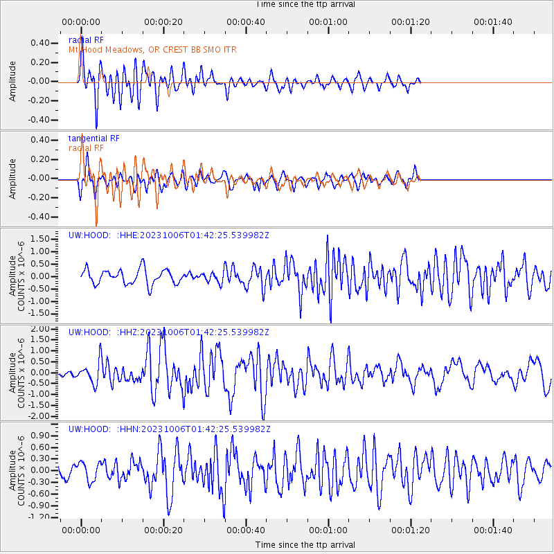
HOOD Mt Hood Meadows, OR CREST BB SMO - Earthquake Result Viewer
*The percent match for this event was below the threshold and hence no stack was calculated.
| Earthquake location: |
Southeast Of Honshu, Japan |
| Earthquake latitude/longitude: |
30.0/140.0 |
| Earthquake time(UTC): |
2023/10/06 (279) 01:31:17 GMT |
| Earthquake Depth: |
10 km |
| Earthquake Magnitude: |
6.1 mww |
| Earthquake Catalog/Contributor: |
NEIC PDE/us |
|
| Network: |
UW Pacific Northwest Regional Seismic Network |
| Station: |
HOOD Mt Hood Meadows, OR CREST BB SMO |
| Lat/Lon: |
45.32 N/121.65 W |
| Elevation: |
1520 m |
|
| Distance: |
74.7 deg |
| Az: |
46.368 deg |
| Baz: |
297.184 deg |
| Ray Param: |
$rayparam |
*The percent match for this event was below the threshold and hence was not used in the summary stack. |
|
| Radial Match: |
77.79921 % |
| Radial Bump: |
400 |
| Transverse Match: |
68.03285 % |
| Transverse Bump: |
400 |
| SOD ConfigId: |
31937991 |
| Insert Time: |
2023-10-20 02:07:55.170 +0000 |
| GWidth: |
2.5 |
| Max Bumps: |
400 |
| Tol: |
0.001 |
|
Signal To Noise
| Channel | StoN | STA | LTA |
| UW:HOOD: :HHZ:20231006T01:42:25.539982Z | 3.1156917 | 5.035881E-7 | 1.6162964E-7 |
| UW:HOOD: :HHN:20231006T01:42:25.539982Z | 1.4197723 | 2.430484E-7 | 1.711883E-7 |
| UW:HOOD: :HHE:20231006T01:42:25.539982Z | 0.7093594 | 2.0777064E-7 | 2.9289896E-7 |
| Arrivals |
| Ps | |
| PpPs | |
| PsPs/PpSs | |


