You are here: Home > Network List > UW - Pacific Northwest Regional Seismic Network Stations List
> Station HOPR Tall Timber Retreat WA > Earthquake Result Viewer
HOPR Tall Timber Retreat WA - Earthquake Result Viewer
| Earthquake location: |
Southeast Of Honshu, Japan |
| Earthquake latitude/longitude: |
30.0/140.0 |
| Earthquake time(UTC): |
2023/10/06 (279) 01:31:17 GMT |
| Earthquake Depth: |
10 km |
| Earthquake Magnitude: |
6.1 mww |
| Earthquake Catalog/Contributor: |
NEIC PDE/us |
|
| Network: |
UW Pacific Northwest Regional Seismic Network |
| Station: |
HOPR Tall Timber Retreat WA |
| Lat/Lon: |
47.92 N/120.89 W |
| Elevation: |
597 m |
|
| Distance: |
74.0 deg |
| Az: |
43.714 deg |
| Baz: |
297.016 deg |
| Ray Param: |
0.05267013 |
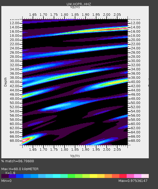
| Estimated Moho Depth: |
68.0 km |
| Estimated Crust Vp/Vs: |
1.60 |
| Assumed Crust Vp: |
6.597 km/s |
| Estimated Crust Vs: |
4.123 km/s |
| Estimated Crust Poisson's Ratio: |
0.18 |
|
| Radial Match: |
86.78688 % |
| Radial Bump: |
400 |
| Transverse Match: |
73.96654 % |
| Transverse Bump: |
400 |
| SOD ConfigId: |
31937991 |
| Insert Time: |
2023-10-20 02:07:58.358 +0000 |
| GWidth: |
2.5 |
| Max Bumps: |
400 |
| Tol: |
0.001 |
|

Signal To Noise
| Channel | StoN | STA | LTA |
| UW:HOPR: :HHZ:20231006T01:42:21.34998Z | 2.9209352 | 3.6826196E-7 | 1.2607673E-7 |
| UW:HOPR: :HHN:20231006T01:42:21.34998Z | 1.2244153 | 1.3656116E-7 | 1.1153173E-7 |
| UW:HOPR: :HHE:20231006T01:42:21.34998Z | 1.5884286 | 1.3951323E-7 | 8.783097E-8 |
| Arrivals |
| Ps | 6.4 SECOND |
| PpPs | 26 SECOND |
| PsPs/PpSs | 32 SECOND |


