You are here: Home > Network List > WI - West Indies IPGP Network Stations List
> Station BIM Morne Bigot, Anses d'Arlets, Martinique > Earthquake Result Viewer
BIM Morne Bigot, Anses d'Arlets, Martinique - Earthquake Result Viewer
| Earthquake location: |
Near Coast Of Central Chile |
| Earthquake latitude/longitude: |
-30.1/-71.4 |
| Earthquake time(UTC): |
2019/01/20 (020) 01:32:51 GMT |
| Earthquake Depth: |
53 km |
| Earthquake Magnitude: |
6.7 mww |
| Earthquake Catalog/Contributor: |
NEIC PDE/us |
|
| Network: |
WI West Indies IPGP Network |
| Station: |
BIM Morne Bigot, Anses d'Arlets, Martinique |
| Lat/Lon: |
14.52 N/61.07 W |
| Elevation: |
391 m |
|
| Distance: |
45.4 deg |
| Az: |
14.144 deg |
| Baz: |
192.634 deg |
| Ray Param: |
0.07112516 |
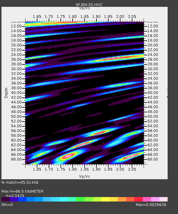
| Estimated Moho Depth: |
66.5 km |
| Estimated Crust Vp/Vs: |
2.04 |
| Assumed Crust Vp: |
5.88 km/s |
| Estimated Crust Vs: |
2.879 km/s |
| Estimated Crust Poisson's Ratio: |
0.34 |
|
| Radial Match: |
85.51446 % |
| Radial Bump: |
400 |
| Transverse Match: |
79.11562 % |
| Transverse Bump: |
400 |
| SOD ConfigId: |
3260311 |
| Insert Time: |
2019-02-03 01:45:26.495 +0000 |
| GWidth: |
2.5 |
| Max Bumps: |
400 |
| Tol: |
0.001 |
|
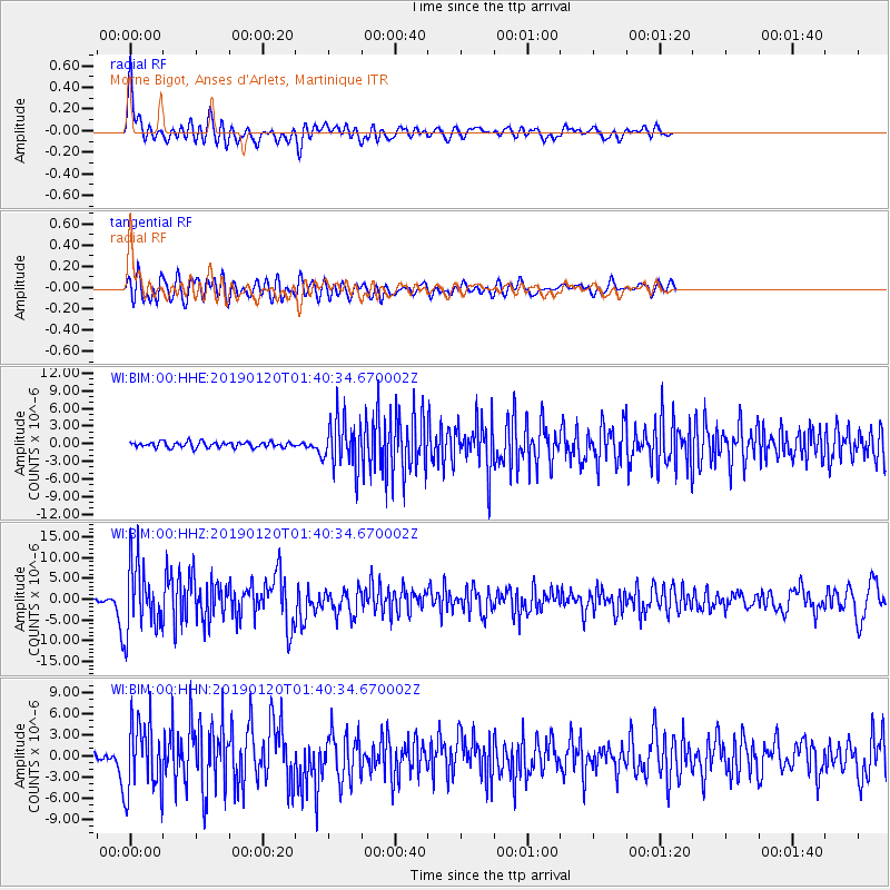
Signal To Noise
| Channel | StoN | STA | LTA |
| WI:BIM:00:HHZ:20190120T01:40:34.670002Z | 26.27665 | 8.378256E-6 | 3.1884795E-7 |
| WI:BIM:00:HHN:20190120T01:40:34.670002Z | 15.217269 | 5.0419176E-6 | 3.3132866E-7 |
| WI:BIM:00:HHE:20190120T01:40:34.670002Z | 8.660699 | 4.1263493E-6 | 4.7644534E-7 |
| Arrivals |
| Ps | 12 SECOND |
| PpPs | 33 SECOND |
| PsPs/PpSs | 45 SECOND |


