You are here: Home > Network List > WY - Yellowstone Wyoming Seismic Network Stations List
> Station YDD Grant Village, YNP, WY, USA old TA-H17A > Earthquake Result Viewer
YDD Grant Village, YNP, WY, USA old TA-H17A - Earthquake Result Viewer
| Earthquake location: |
Near Coast Of Central Chile |
| Earthquake latitude/longitude: |
-30.1/-71.4 |
| Earthquake time(UTC): |
2019/01/20 (020) 01:32:51 GMT |
| Earthquake Depth: |
53 km |
| Earthquake Magnitude: |
6.7 mww |
| Earthquake Catalog/Contributor: |
NEIC PDE/us |
|
| Network: |
WY Yellowstone Wyoming Seismic Network |
| Station: |
YDD Grant Village, YNP, WY, USA old TA-H17A |
| Lat/Lon: |
44.40 N/110.58 W |
| Elevation: |
2400 m |
|
| Distance: |
82.3 deg |
| Az: |
332.821 deg |
| Baz: |
146.474 deg |
| Ray Param: |
0.04689964 |
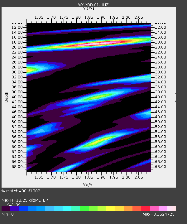
| Estimated Moho Depth: |
18.25 km |
| Estimated Crust Vp/Vs: |
1.89 |
| Assumed Crust Vp: |
6.35 km/s |
| Estimated Crust Vs: |
3.36 km/s |
| Estimated Crust Poisson's Ratio: |
0.31 |
|
| Radial Match: |
80.61382 % |
| Radial Bump: |
400 |
| Transverse Match: |
83.33787 % |
| Transverse Bump: |
400 |
| SOD ConfigId: |
3260311 |
| Insert Time: |
2019-02-03 01:45:40.272 +0000 |
| GWidth: |
2.5 |
| Max Bumps: |
400 |
| Tol: |
0.001 |
|

Signal To Noise
| Channel | StoN | STA | LTA |
| WY:YDD:01:HHZ:20190120T01:44:36.190022Z | 16.026611 | 1.169197E-7 | 7.2953474E-9 |
| WY:YDD:01:HHN:20190120T01:44:36.190022Z | 9.345095 | 7.1278016E-8 | 7.627318E-9 |
| WY:YDD:01:HHE:20190120T01:44:36.190022Z | 4.329018 | 4.4553214E-8 | 1.02917594E-8 |
| Arrivals |
| Ps | 2.6 SECOND |
| PpPs | 8.1 SECOND |
| PsPs/PpSs | 11 SECOND |


