You are here: Home > Network List > WY - Yellowstone Wyoming Seismic Network Stations List
> Station YHH Holmes Hill, YNP, WY, USA > Earthquake Result Viewer
YHH Holmes Hill, YNP, WY, USA - Earthquake Result Viewer
| Earthquake location: |
Near Coast Of Central Chile |
| Earthquake latitude/longitude: |
-30.1/-71.4 |
| Earthquake time(UTC): |
2019/01/20 (020) 01:32:51 GMT |
| Earthquake Depth: |
53 km |
| Earthquake Magnitude: |
6.7 mww |
| Earthquake Catalog/Contributor: |
NEIC PDE/us |
|
| Network: |
WY Yellowstone Wyoming Seismic Network |
| Station: |
YHH Holmes Hill, YNP, WY, USA |
| Lat/Lon: |
44.79 N/110.85 W |
| Elevation: |
2717 m |
|
| Distance: |
82.7 deg |
| Az: |
332.876 deg |
| Baz: |
146.289 deg |
| Ray Param: |
0.046597514 |
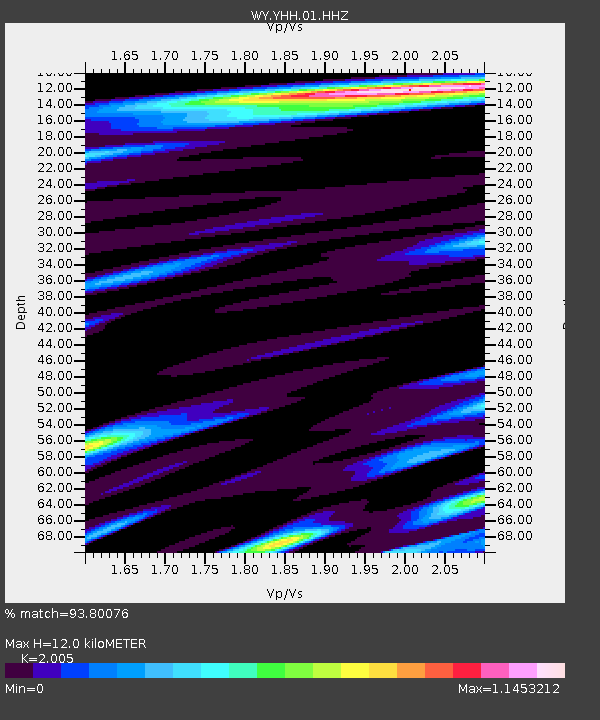
| Estimated Moho Depth: |
12.0 km |
| Estimated Crust Vp/Vs: |
2.01 |
| Assumed Crust Vp: |
6.35 km/s |
| Estimated Crust Vs: |
3.167 km/s |
| Estimated Crust Poisson's Ratio: |
0.33 |
|
| Radial Match: |
93.80076 % |
| Radial Bump: |
400 |
| Transverse Match: |
86.59749 % |
| Transverse Bump: |
400 |
| SOD ConfigId: |
3260311 |
| Insert Time: |
2019-02-03 01:45:47.080 +0000 |
| GWidth: |
2.5 |
| Max Bumps: |
400 |
| Tol: |
0.001 |
|
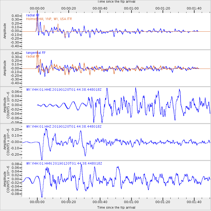
Signal To Noise
| Channel | StoN | STA | LTA |
| WY:YHH:01:HHZ:20190120T01:44:38.448018Z | 21.438585 | 1.2590543E-7 | 5.872842E-9 |
| WY:YHH:01:HHN:20190120T01:44:38.448018Z | 4.6536083 | 4.230741E-8 | 9.091313E-9 |
| WY:YHH:01:HHE:20190120T01:44:38.448018Z | 2.2389715 | 1.5882966E-8 | 7.093867E-9 |
| Arrivals |
| Ps | 1.9 SECOND |
| PpPs | 5.6 SECOND |
| PsPs/PpSs | 7.5 SECOND |


