You are here: Home > Network List > UU - University of Utah Regional Network Stations List
> Station FORU South Mineral Mountains, UT, USA > Earthquake Result Viewer
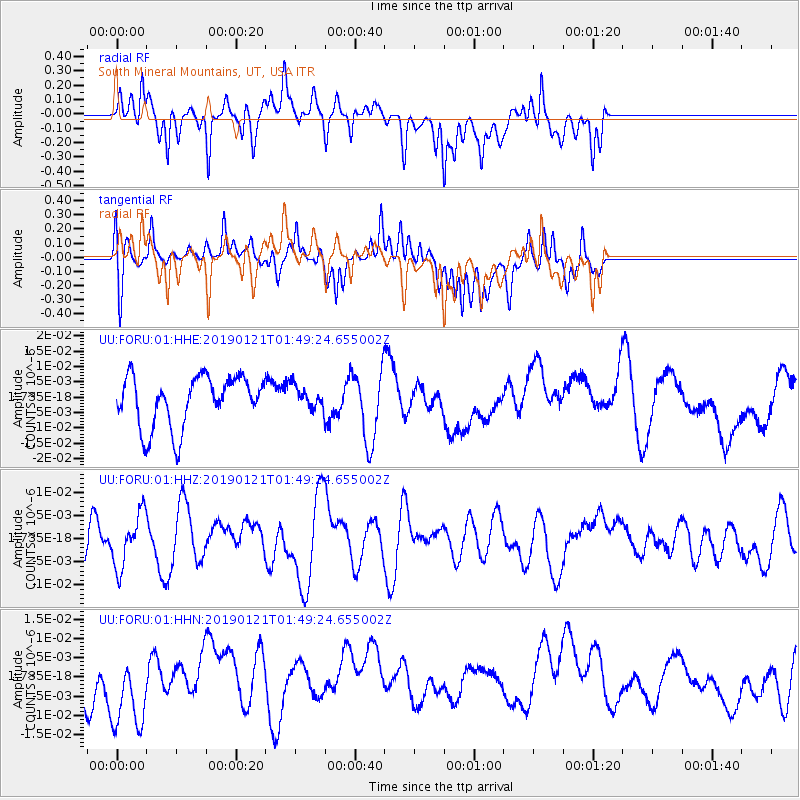
FORU South Mineral Mountains, UT, USA - Earthquake Result Viewer
*The percent match for this event was below the threshold and hence no stack was calculated.
| Earthquake location: |
Southeast Of Loyalty Islands |
| Earthquake latitude/longitude: |
-21.9/169.1 |
| Earthquake time(UTC): |
2019/01/21 (021) 01:36:36 GMT |
| Earthquake Depth: |
10 km |
| Earthquake Magnitude: |
5.7 Mww |
| Earthquake Catalog/Contributor: |
NEIC PDE/us |
|
| Network: |
UU University of Utah Regional Network |
| Station: |
FORU South Mineral Mountains, UT, USA |
| Lat/Lon: |
38.46 N/112.86 W |
| Elevation: |
1840 m |
|
| Distance: |
94.5 deg |
| Az: |
50.383 deg |
| Baz: |
245.712 deg |
| Ray Param: |
$rayparam |
*The percent match for this event was below the threshold and hence was not used in the summary stack. |
|
| Radial Match: |
56.14863 % |
| Radial Bump: |
400 |
| Transverse Match: |
55.90724 % |
| Transverse Bump: |
400 |
| SOD ConfigId: |
3260311 |
| Insert Time: |
2019-02-04 01:44:19.246 +0000 |
| GWidth: |
2.5 |
| Max Bumps: |
400 |
| Tol: |
0.001 |
|
Signal To Noise
| Channel | StoN | STA | LTA |
| UU:FORU:01:HHZ:20190121T01:49:24.655002Z | 1.3235481 | 5.7968084E-9 | 4.3797495E-9 |
| UU:FORU:01:HHN:20190121T01:49:24.655002Z | 1.7250736 | 1.0298306E-8 | 5.969778E-9 |
| UU:FORU:01:HHE:20190121T01:49:24.655002Z | 0.44580957 | 3.6802452E-9 | 8.255195E-9 |
| Arrivals |
| Ps | |
| PpPs | |
| PsPs/PpSs | |


