You are here: Home > Network List > G - GEOSCOPE Stations List
> Station ATD Arta Cave - Arta, Republic of Djibouti > Earthquake Result Viewer
ATD Arta Cave - Arta, Republic of Djibouti - Earthquake Result Viewer
| Earthquake location: |
Sumba Region, Indonesia |
| Earthquake latitude/longitude: |
-10.3/119.1 |
| Earthquake time(UTC): |
2019/01/21 (021) 23:59:22 GMT |
| Earthquake Depth: |
17 km |
| Earthquake Magnitude: |
6.0 Mww |
| Earthquake Catalog/Contributor: |
NEIC PDE/us |
|
| Network: |
G GEOSCOPE |
| Station: |
ATD Arta Cave - Arta, Republic of Djibouti |
| Lat/Lon: |
11.53 N/42.85 E |
| Elevation: |
610 m |
|
| Distance: |
78.9 deg |
| Az: |
283.961 deg |
| Baz: |
102.992 deg |
| Ray Param: |
0.04933851 |
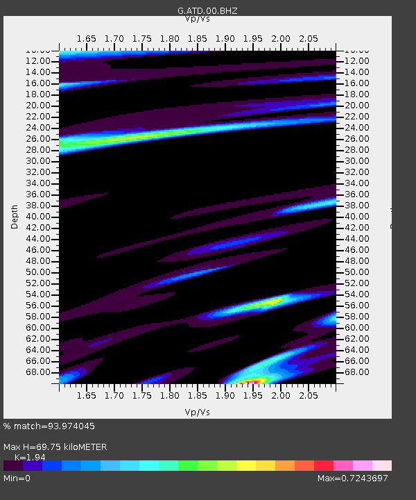
| Estimated Moho Depth: |
69.75 km |
| Estimated Crust Vp/Vs: |
1.94 |
| Assumed Crust Vp: |
6.375 km/s |
| Estimated Crust Vs: |
3.286 km/s |
| Estimated Crust Poisson's Ratio: |
0.32 |
|
| Radial Match: |
93.974045 % |
| Radial Bump: |
400 |
| Transverse Match: |
80.46929 % |
| Transverse Bump: |
400 |
| SOD ConfigId: |
3260311 |
| Insert Time: |
2019-02-05 00:14:48.051 +0000 |
| GWidth: |
2.5 |
| Max Bumps: |
400 |
| Tol: |
0.001 |
|
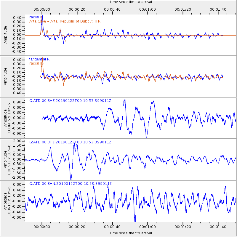
Signal To Noise
| Channel | StoN | STA | LTA |
| G:ATD:00:BHZ:20190122T00:10:53.399011Z | 4.9364305 | 4.637776E-7 | 9.395E-8 |
| G:ATD:00:BHN:20190122T00:10:53.399011Z | 0.7984407 | 7.983156E-8 | 9.9984334E-8 |
| G:ATD:00:BHE:20190122T00:10:53.399011Z | 2.0343864 | 1.6601152E-7 | 8.160275E-8 |
| Arrivals |
| Ps | 11 SECOND |
| PpPs | 31 SECOND |
| PsPs/PpSs | 42 SECOND |


