You are here: Home > Network List > CI - Caltech Regional Seismic Network Stations List
> Station MPP McPhearson Peak > Earthquake Result Viewer
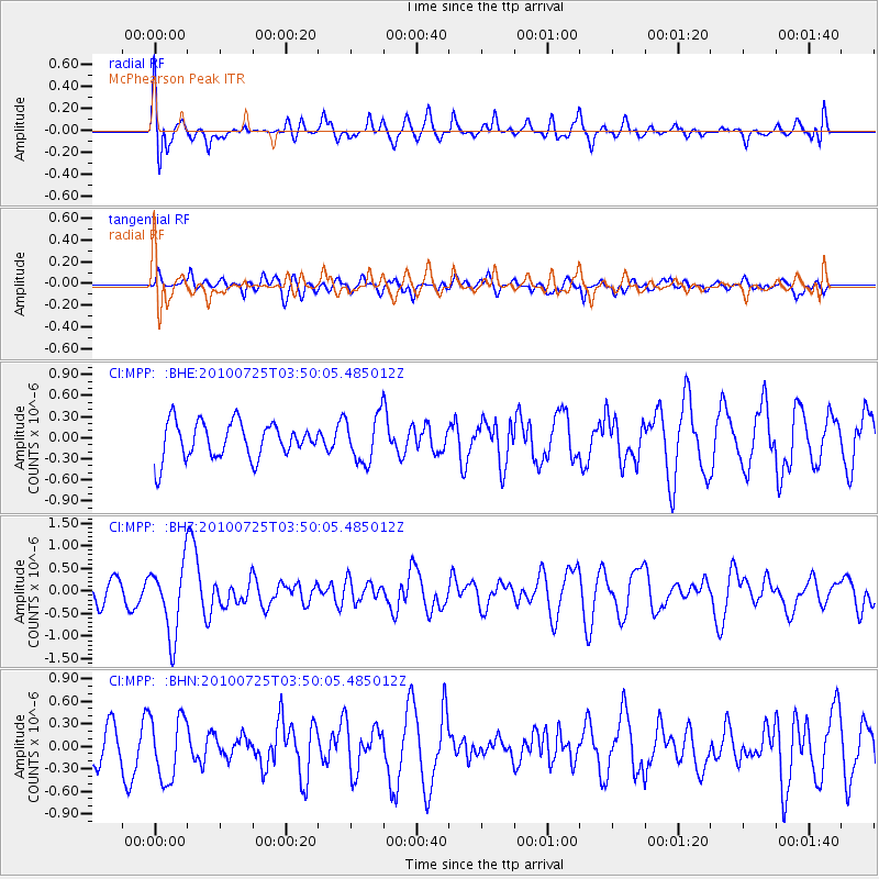
MPP McPhearson Peak - Earthquake Result Viewer
*The percent match for this event was below the threshold and hence no stack was calculated.
| Earthquake location: |
Tonga Islands |
| Earthquake latitude/longitude: |
-15.1/-173.5 |
| Earthquake time(UTC): |
2010/07/25 (206) 03:39:17 GMT |
| Earthquake Depth: |
7.0 km |
| Earthquake Magnitude: |
5.6 MB, 5.7 MS, 5.9 MW, 5.9 MW |
| Earthquake Catalog/Contributor: |
WHDF/NEIC |
|
| Network: |
CI Caltech Regional Seismic Network |
| Station: |
MPP McPhearson Peak |
| Lat/Lon: |
34.89 N/119.81 W |
| Elevation: |
1739 m |
|
| Distance: |
71.2 deg |
| Az: |
44.449 deg |
| Baz: |
235.378 deg |
| Ray Param: |
$rayparam |
*The percent match for this event was below the threshold and hence was not used in the summary stack. |
|
| Radial Match: |
68.09912 % |
| Radial Bump: |
400 |
| Transverse Match: |
53.392475 % |
| Transverse Bump: |
400 |
| SOD ConfigId: |
319893 |
| Insert Time: |
2011-01-05 10:44:06.011 +0000 |
| GWidth: |
2.5 |
| Max Bumps: |
400 |
| Tol: |
0.001 |
|
Signal To Noise
| Channel | StoN | STA | LTA |
| CI:MPP: :BHZ:20100725T03:50:05.485012Z | 4.045809 | 7.8012647E-7 | 1.9282338E-7 |
| CI:MPP: :BHN:20100725T03:50:05.485012Z | 1.1187955 | 4.2356336E-7 | 3.785887E-7 |
| CI:MPP: :BHE:20100725T03:50:05.485012Z | 1.2860686 | 3.3064674E-7 | 2.5709883E-7 |
| Arrivals |
| Ps | |
| PpPs | |
| PsPs/PpSs | |


