You are here: Home > Network List > PS - Pacific21 Stations List
> Station PATS 6onpei, Micronesia > Earthquake Result Viewer
PATS 6onpei, Micronesia - Earthquake Result Viewer

| Earthquake location: |
Tonga Islands |
| Earthquake latitude/longitude: |
-15.1/-173.5 |
| Earthquake time(UTC): |
2010/07/25 (206) 03:39:17 GMT |
| Earthquake Depth: |
7.0 km |
| Earthquake Magnitude: |
5.6 MB, 5.7 MS, 5.9 MW, 5.9 MW |
| Earthquake Catalog/Contributor: |
WHDF/NEIC |
|
| Network: |
PS Pacific21 |
| Station: |
PATS 6onpei, Micronesia |
| Lat/Lon: |
6.84 N/158.32 E |
| Elevation: |
10 m |
|
| Distance: |
35.4 deg |
| Az: |
306.02 deg |
| Baz: |
128.106 deg |
| Ray Param: |
0.07726299 |
| Estimated Moho Depth: |
50.25 km |
| Estimated Crust Vp/Vs: |
1.76 |
| Assumed Crust Vp: |
4.24 km/s |
| Estimated Crust Vs: |
2.402 km/s |
| Estimated Crust Poisson's Ratio: |
0.26 |
|
| Radial Match: |
80.26483 % |
| Radial Bump: |
400 |
| Transverse Match: |
56.103394 % |
| Transverse Bump: |
400 |
| SOD ConfigId: |
319893 |
| Insert Time: |
2011-01-05 10:49:52.842 +0000 |
| GWidth: |
2.5 |
| Max Bumps: |
400 |
| Tol: |
0.001 |
|
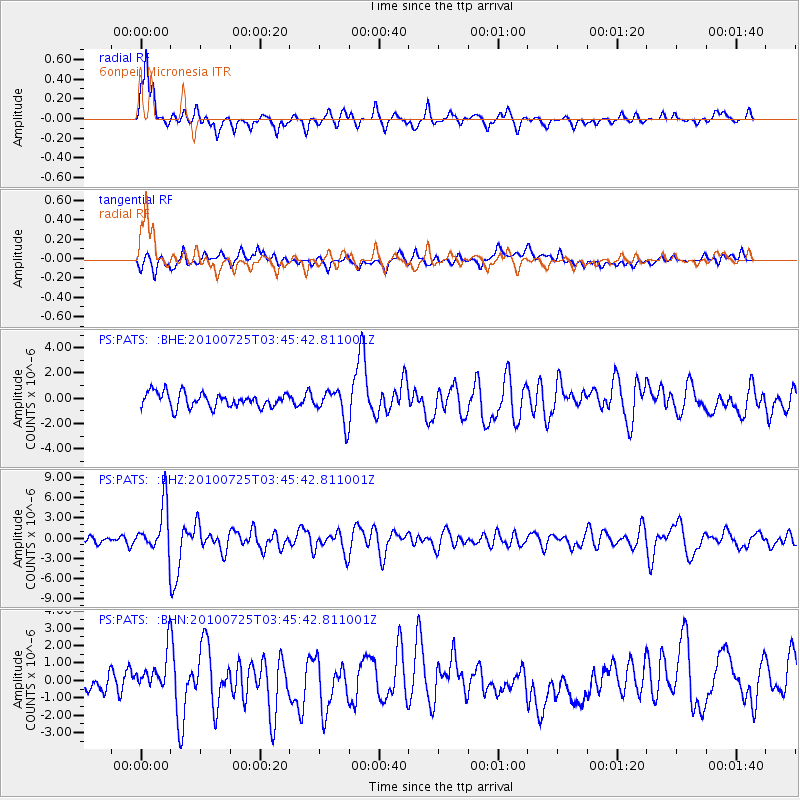
Signal To Noise
| Channel | StoN | STA | LTA |
| PS:PATS: :BHZ:20100725T03:45:42.811001Z | 4.653473 | 3.4791433E-6 | 7.476445E-7 |
| PS:PATS: :BHN:20100725T03:45:42.811001Z | 2.0854187 | 1.1381029E-6 | 5.4574315E-7 |
| PS:PATS: :BHE:20100725T03:45:42.811001Z | 2.1606338 | 1.2367387E-6 | 5.723963E-7 |
| Arrivals |
| Ps | 9.4 SECOND |
| PpPs | 32 SECOND |
| PsPs/PpSs | 41 SECOND |


