You are here: Home > Network List > TA - USArray Transportable Network (new EarthScope stations) Stations List
> Station T25A Trinidad, CO, USA > Earthquake Result Viewer
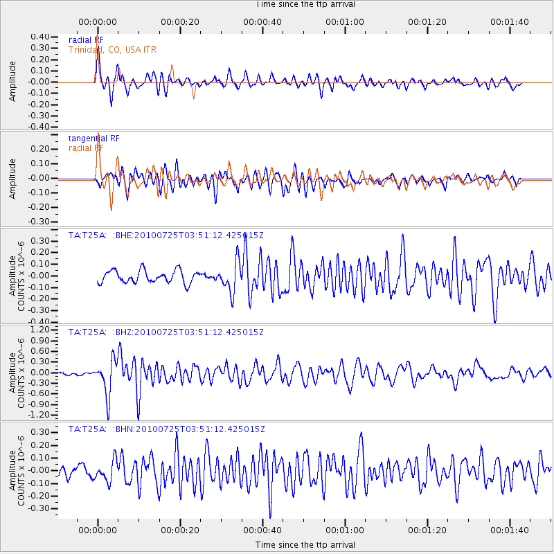
T25A Trinidad, CO, USA - Earthquake Result Viewer
*The percent match for this event was below the threshold and hence no stack was calculated.
| Earthquake location: |
Tonga Islands |
| Earthquake latitude/longitude: |
-15.1/-173.5 |
| Earthquake time(UTC): |
2010/07/25 (206) 03:39:17 GMT |
| Earthquake Depth: |
7.0 km |
| Earthquake Magnitude: |
5.6 MB, 5.7 MS, 5.9 MW, 5.9 MW |
| Earthquake Catalog/Contributor: |
WHDF/NEIC |
|
| Network: |
TA USArray Transportable Network (new EarthScope stations) |
| Station: |
T25A Trinidad, CO, USA |
| Lat/Lon: |
37.14 N/104.41 W |
| Elevation: |
2017 m |
|
| Distance: |
83.1 deg |
| Az: |
48.775 deg |
| Baz: |
245.4 deg |
| Ray Param: |
$rayparam |
*The percent match for this event was below the threshold and hence was not used in the summary stack. |
|
| Radial Match: |
79.76599 % |
| Radial Bump: |
398 |
| Transverse Match: |
75.71342 % |
| Transverse Bump: |
400 |
| SOD ConfigId: |
319893 |
| Insert Time: |
2011-01-05 10:50:54.988 +0000 |
| GWidth: |
2.5 |
| Max Bumps: |
400 |
| Tol: |
0.001 |
|
Signal To Noise
| Channel | StoN | STA | LTA |
| TA:T25A: :BHZ:20100725T03:51:12.425015Z | 7.65055 | 5.069879E-7 | 6.6268164E-8 |
| TA:T25A: :BHN:20100725T03:51:12.425015Z | 2.0391924 | 8.2368906E-8 | 4.039291E-8 |
| TA:T25A: :BHE:20100725T03:51:12.425015Z | 2.4761605 | 1.3218512E-7 | 5.33831E-8 |
| Arrivals |
| Ps | |
| PpPs | |
| PsPs/PpSs | |


