You are here: Home > Network List > TA - USArray Transportable Network (new EarthScope stations) Stations List
> Station J21A Lysite, WY, USA > Earthquake Result Viewer
J21A Lysite, WY, USA - Earthquake Result Viewer
| Earthquake location: |
Tonga Islands |
| Earthquake latitude/longitude: |
-15.1/-173.5 |
| Earthquake time(UTC): |
2010/07/25 (206) 03:39:17 GMT |
| Earthquake Depth: |
7.0 km |
| Earthquake Magnitude: |
5.6 MB, 5.7 MS, 5.9 MW, 5.9 MW |
| Earthquake Catalog/Contributor: |
WHDF/NEIC |
|
| Network: |
TA USArray Transportable Network (new EarthScope stations) |
| Station: |
J21A Lysite, WY, USA |
| Lat/Lon: |
43.35 N/107.45 W |
| Elevation: |
1913 m |
|
| Distance: |
83.8 deg |
| Az: |
42.141 deg |
| Baz: |
242.686 deg |
| Ray Param: |
0.045968316 |
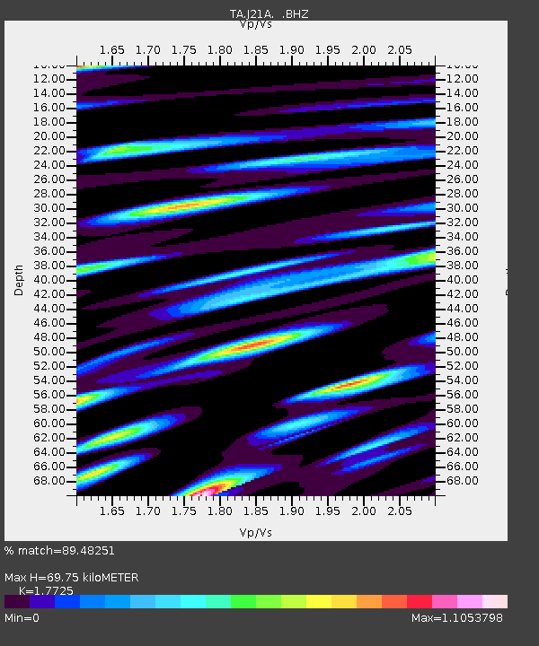
| Estimated Moho Depth: |
69.75 km |
| Estimated Crust Vp/Vs: |
1.77 |
| Assumed Crust Vp: |
6.178 km/s |
| Estimated Crust Vs: |
3.486 km/s |
| Estimated Crust Poisson's Ratio: |
0.27 |
|
| Radial Match: |
89.48251 % |
| Radial Bump: |
400 |
| Transverse Match: |
86.36957 % |
| Transverse Bump: |
400 |
| SOD ConfigId: |
319893 |
| Insert Time: |
2011-01-05 10:52:04.339 +0000 |
| GWidth: |
2.5 |
| Max Bumps: |
400 |
| Tol: |
0.001 |
|
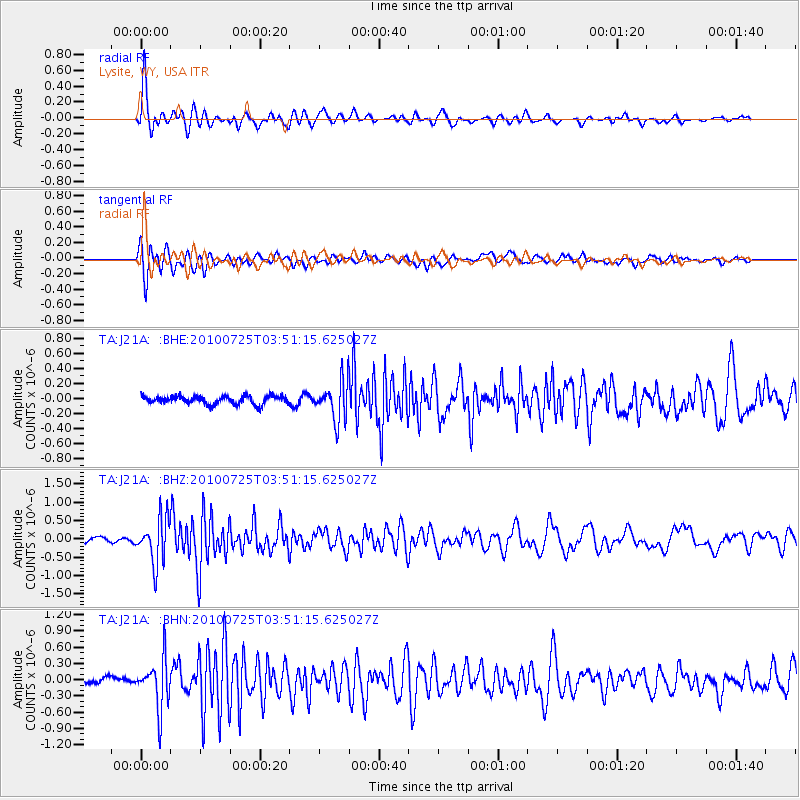
Signal To Noise
| Channel | StoN | STA | LTA |
| TA:J21A: :BHZ:20100725T03:51:15.625027Z | 7.3163843 | 6.083347E-7 | 8.31469E-8 |
| TA:J21A: :BHN:20100725T03:51:15.625027Z | 5.098052 | 4.5167474E-7 | 8.859752E-8 |
| TA:J21A: :BHE:20100725T03:51:15.625027Z | 4.787492 | 2.6087096E-7 | 5.4490112E-8 |
| Arrivals |
| Ps | 8.9 SECOND |
| PpPs | 31 SECOND |
| PsPs/PpSs | 40 SECOND |


