You are here: Home > Network List > TA - USArray Transportable Network (new EarthScope stations) Stations List
> Station TUL1 Leonard, OK, USA > Earthquake Result Viewer
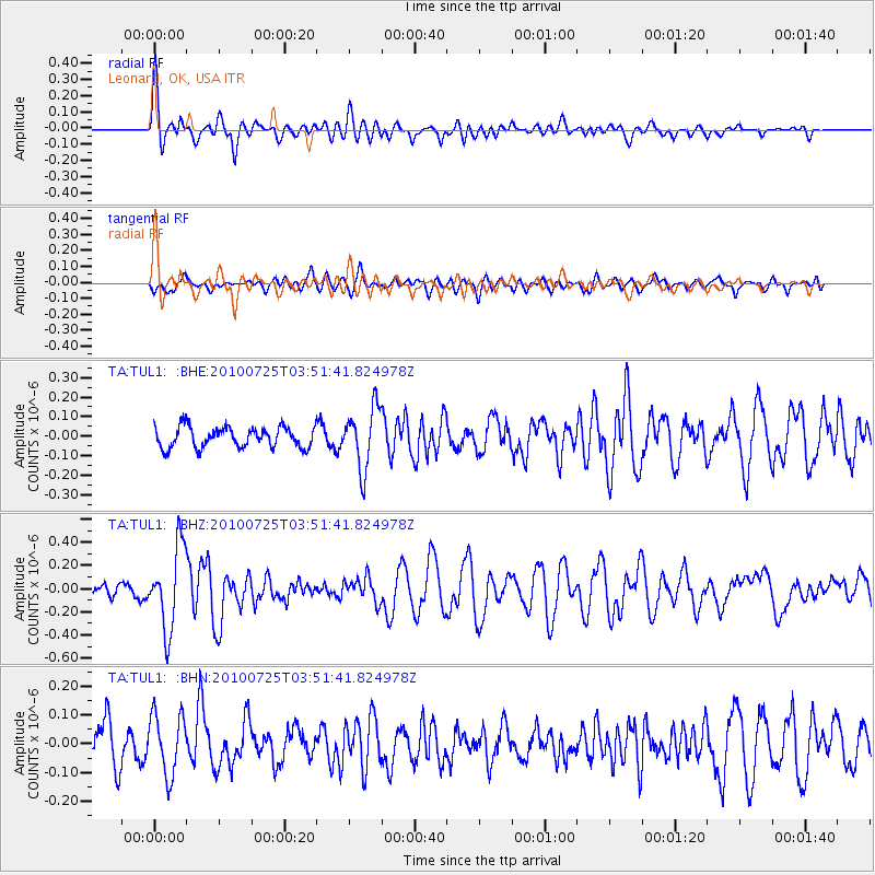
TUL1 Leonard, OK, USA - Earthquake Result Viewer
*The percent match for this event was below the threshold and hence no stack was calculated.
| Earthquake location: |
Tonga Islands |
| Earthquake latitude/longitude: |
-15.1/-173.5 |
| Earthquake time(UTC): |
2010/07/25 (206) 03:39:17 GMT |
| Earthquake Depth: |
7.0 km |
| Earthquake Magnitude: |
5.6 MB, 5.7 MS, 5.9 MW, 5.9 MW |
| Earthquake Catalog/Contributor: |
WHDF/NEIC |
|
| Network: |
TA USArray Transportable Network (new EarthScope stations) |
| Station: |
TUL1 Leonard, OK, USA |
| Lat/Lon: |
35.91 N/95.79 W |
| Elevation: |
256 m |
|
| Distance: |
89.1 deg |
| Az: |
52.507 deg |
| Baz: |
250.767 deg |
| Ray Param: |
$rayparam |
*The percent match for this event was below the threshold and hence was not used in the summary stack. |
|
| Radial Match: |
78.611565 % |
| Radial Bump: |
400 |
| Transverse Match: |
51.22384 % |
| Transverse Bump: |
400 |
| SOD ConfigId: |
319893 |
| Insert Time: |
2011-01-05 10:53:32.762 +0000 |
| GWidth: |
2.5 |
| Max Bumps: |
400 |
| Tol: |
0.001 |
|
Signal To Noise
| Channel | StoN | STA | LTA |
| TA:TUL1: :BHZ:20100725T03:51:41.824978Z | 7.083187 | 3.5395368E-7 | 4.9970964E-8 |
| TA:TUL1: :BHN:20100725T03:51:41.824978Z | 1.7555743 | 1.0427289E-7 | 5.939532E-8 |
| TA:TUL1: :BHE:20100725T03:51:41.824978Z | 2.9796703 | 1.5668442E-7 | 5.2584483E-8 |
| Arrivals |
| Ps | |
| PpPs | |
| PsPs/PpSs | |


