You are here: Home > Network List > TA - USArray Transportable Network (new EarthScope stations) Stations List
> Station K27A Flueckinger Farm, Gordon, NE, USA > Earthquake Result Viewer
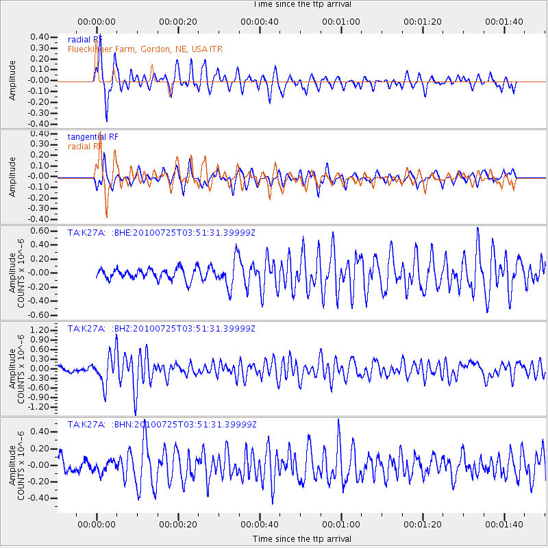
K27A Flueckinger Farm, Gordon, NE, USA - Earthquake Result Viewer
*The percent match for this event was below the threshold and hence no stack was calculated.
| Earthquake location: |
Tonga Islands |
| Earthquake latitude/longitude: |
-15.1/-173.5 |
| Earthquake time(UTC): |
2010/07/25 (206) 03:39:17 GMT |
| Earthquake Depth: |
7.0 km |
| Earthquake Magnitude: |
5.6 MB, 5.7 MS, 5.9 MW, 5.9 MW |
| Earthquake Catalog/Contributor: |
WHDF/NEIC |
|
| Network: |
TA USArray Transportable Network (new EarthScope stations) |
| Station: |
K27A Flueckinger Farm, Gordon, NE, USA |
| Lat/Lon: |
42.70 N/102.24 W |
| Elevation: |
1131 m |
|
| Distance: |
86.9 deg |
| Az: |
44.369 deg |
| Baz: |
246.41 deg |
| Ray Param: |
$rayparam |
*The percent match for this event was below the threshold and hence was not used in the summary stack. |
|
| Radial Match: |
75.695946 % |
| Radial Bump: |
359 |
| Transverse Match: |
54.664577 % |
| Transverse Bump: |
367 |
| SOD ConfigId: |
319893 |
| Insert Time: |
2011-01-05 10:54:46.258 +0000 |
| GWidth: |
2.5 |
| Max Bumps: |
400 |
| Tol: |
0.001 |
|
Signal To Noise
| Channel | StoN | STA | LTA |
| TA:K27A: :BHZ:20100725T03:51:31.39999Z | 6.164414 | 4.801626E-7 | 7.7892665E-8 |
| TA:K27A: :BHN:20100725T03:51:31.39999Z | 0.48455912 | 6.853565E-8 | 1.4143919E-7 |
| TA:K27A: :BHE:20100725T03:51:31.39999Z | 2.6664367 | 2.0406387E-7 | 7.653055E-8 |
| Arrivals |
| Ps | |
| PpPs | |
| PsPs/PpSs | |


