You are here: Home > Network List > G - GEOSCOPE Stations List
> Station TAM Tamanrasset, Algeria > Earthquake Result Viewer
TAM Tamanrasset, Algeria - Earthquake Result Viewer
| Earthquake location: |
Northwestern Afghanistan |
| Earthquake latitude/longitude: |
34.6/61.9 |
| Earthquake time(UTC): |
2023/10/07 (280) 06:41:02 GMT |
| Earthquake Depth: |
10 km |
| Earthquake Magnitude: |
6.2 mww |
| Earthquake Catalog/Contributor: |
NEIC PDE/us |
|
| Network: |
G GEOSCOPE |
| Station: |
TAM Tamanrasset, Algeria |
| Lat/Lon: |
22.79 N/5.53 E |
| Elevation: |
1377 m |
|
| Distance: |
50.3 deg |
| Az: |
272.142 deg |
| Baz: |
63.25 deg |
| Ray Param: |
0.068162814 |
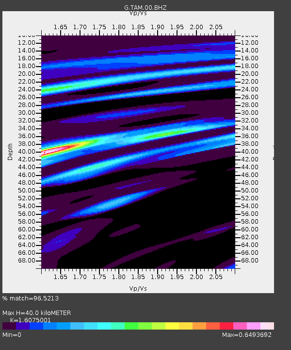
| Estimated Moho Depth: |
40.0 km |
| Estimated Crust Vp/Vs: |
1.61 |
| Assumed Crust Vp: |
6.61 km/s |
| Estimated Crust Vs: |
4.112 km/s |
| Estimated Crust Poisson's Ratio: |
0.18 |
|
| Radial Match: |
96.5213 % |
| Radial Bump: |
224 |
| Transverse Match: |
85.613594 % |
| Transverse Bump: |
400 |
| SOD ConfigId: |
31937991 |
| Insert Time: |
2023-10-21 07:04:13.205 +0000 |
| GWidth: |
2.5 |
| Max Bumps: |
400 |
| Tol: |
0.001 |
|
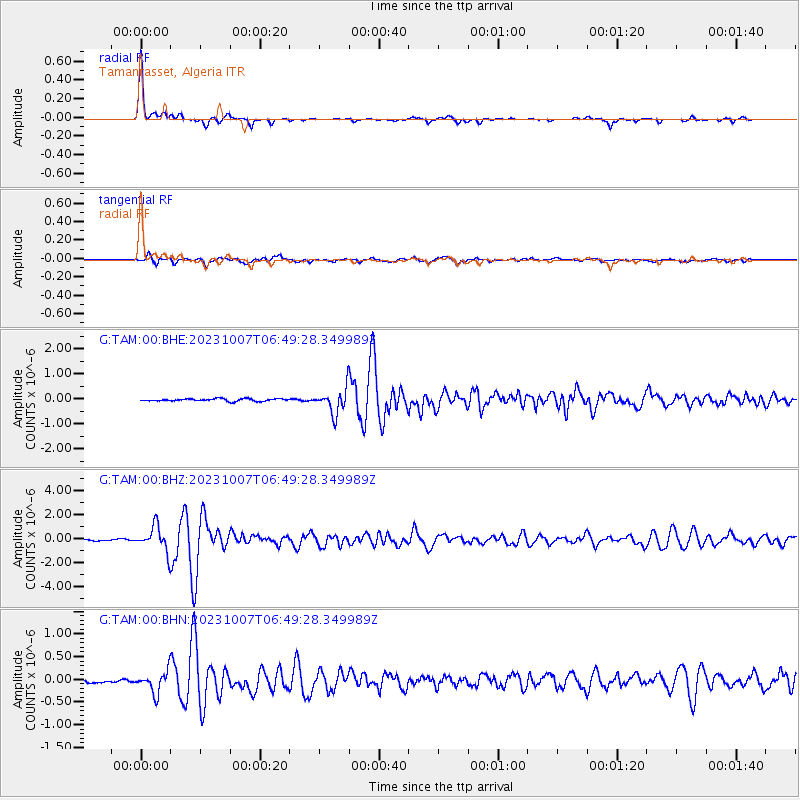
Signal To Noise
| Channel | StoN | STA | LTA |
| G:TAM:00:BHZ:20231007T06:49:28.349989Z | 10.508586 | 1.0360709E-6 | 9.859279E-8 |
| G:TAM:00:BHN:20231007T06:49:28.349989Z | 5.8395114 | 2.3177198E-7 | 3.9690306E-8 |
| G:TAM:00:BHE:20231007T06:49:28.349989Z | 10.25275 | 4.960098E-7 | 4.8378222E-8 |
| Arrivals |
| Ps | 3.9 SECOND |
| PpPs | 15 SECOND |
| PsPs/PpSs | 19 SECOND |


