You are here: Home > Network List > TA - USArray Transportable Network (new EarthScope stations) Stations List
> Station R26A Arlington, CO, USA > Earthquake Result Viewer
R26A Arlington, CO, USA - Earthquake Result Viewer
| Earthquake location: |
Tonga Islands |
| Earthquake latitude/longitude: |
-15.1/-173.5 |
| Earthquake time(UTC): |
2010/07/25 (206) 03:39:17 GMT |
| Earthquake Depth: |
7.0 km |
| Earthquake Magnitude: |
5.6 MB, 5.7 MS, 5.9 MW, 5.9 MW |
| Earthquake Catalog/Contributor: |
WHDF/NEIC |
|
| Network: |
TA USArray Transportable Network (new EarthScope stations) |
| Station: |
R26A Arlington, CO, USA |
| Lat/Lon: |
38.30 N/103.45 W |
| Elevation: |
1304 m |
|
| Distance: |
84.3 deg |
| Az: |
48.029 deg |
| Baz: |
245.906 deg |
| Ray Param: |
0.045583487 |
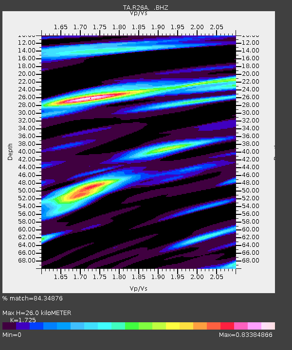
| Estimated Moho Depth: |
26.0 km |
| Estimated Crust Vp/Vs: |
1.73 |
| Assumed Crust Vp: |
6.242 km/s |
| Estimated Crust Vs: |
3.619 km/s |
| Estimated Crust Poisson's Ratio: |
0.25 |
|
| Radial Match: |
84.34876 % |
| Radial Bump: |
332 |
| Transverse Match: |
63.390762 % |
| Transverse Bump: |
351 |
| SOD ConfigId: |
319893 |
| Insert Time: |
2011-01-05 10:55:24.670 +0000 |
| GWidth: |
2.5 |
| Max Bumps: |
400 |
| Tol: |
0.001 |
|
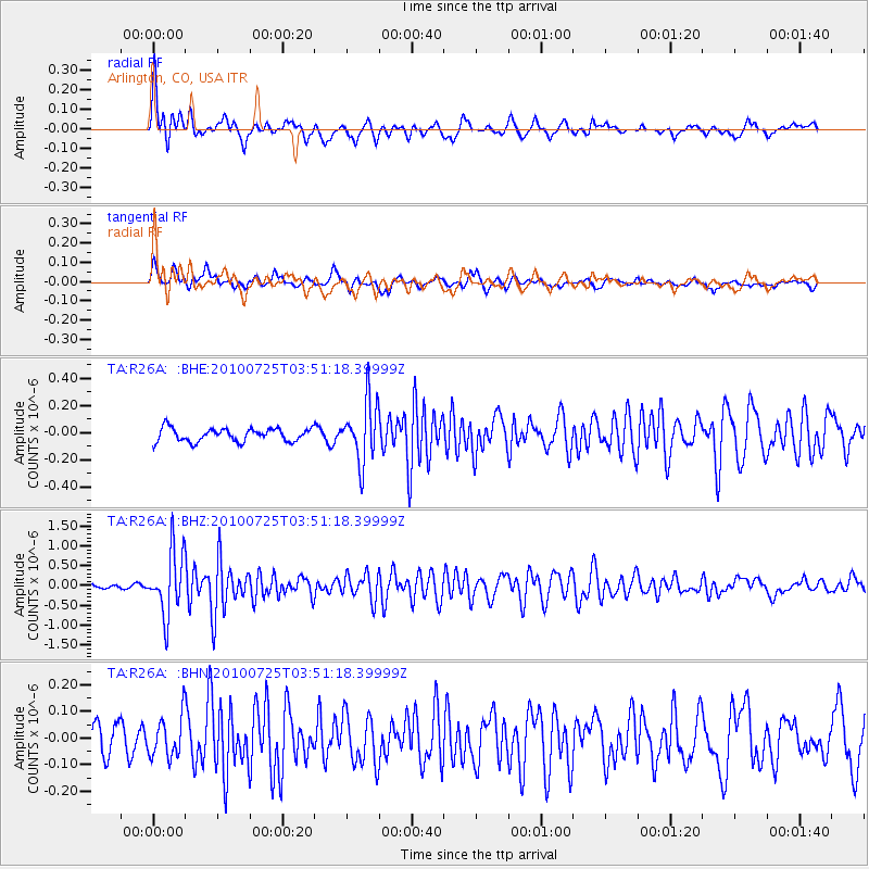
Signal To Noise
| Channel | StoN | STA | LTA |
| TA:R26A: :BHZ:20100725T03:51:18.39999Z | 15.45619 | 7.9276197E-7 | 5.1290904E-8 |
| TA:R26A: :BHN:20100725T03:51:18.39999Z | 1.5526677 | 7.593839E-8 | 4.890833E-8 |
| TA:R26A: :BHE:20100725T03:51:18.39999Z | 4.5915375 | 2.2259573E-7 | 4.8479563E-8 |
| Arrivals |
| Ps | 3.1 SECOND |
| PpPs | 11 SECOND |
| PsPs/PpSs | 14 SECOND |


