You are here: Home > Network List > TA - USArray Transportable Network (new EarthScope stations) Stations List
> Station V28A Channing, TX, USA > Earthquake Result Viewer
V28A Channing, TX, USA - Earthquake Result Viewer
| Earthquake location: |
Tonga Islands |
| Earthquake latitude/longitude: |
-15.1/-173.5 |
| Earthquake time(UTC): |
2010/07/25 (206) 03:39:17 GMT |
| Earthquake Depth: |
7.0 km |
| Earthquake Magnitude: |
5.6 MB, 5.7 MS, 5.9 MW, 5.9 MW |
| Earthquake Catalog/Contributor: |
WHDF/NEIC |
|
| Network: |
TA USArray Transportable Network (new EarthScope stations) |
| Station: |
V28A Channing, TX, USA |
| Lat/Lon: |
35.75 N/102.22 W |
| Elevation: |
1163 m |
|
| Distance: |
84.2 deg |
| Az: |
50.767 deg |
| Baz: |
246.914 deg |
| Ray Param: |
0.045667656 |
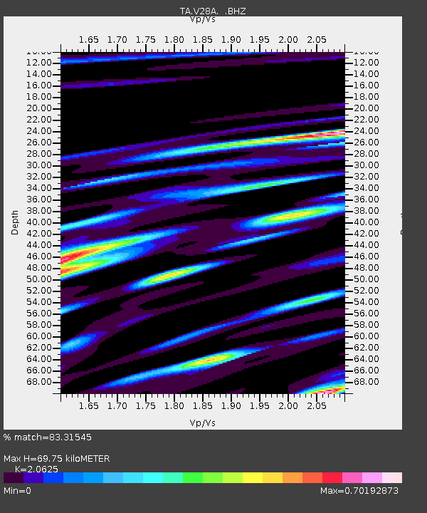
| Estimated Moho Depth: |
69.75 km |
| Estimated Crust Vp/Vs: |
2.06 |
| Assumed Crust Vp: |
6.242 km/s |
| Estimated Crust Vs: |
3.026 km/s |
| Estimated Crust Poisson's Ratio: |
0.35 |
|
| Radial Match: |
83.31545 % |
| Radial Bump: |
400 |
| Transverse Match: |
72.61851 % |
| Transverse Bump: |
400 |
| SOD ConfigId: |
319893 |
| Insert Time: |
2011-01-05 10:56:14.906 +0000 |
| GWidth: |
2.5 |
| Max Bumps: |
400 |
| Tol: |
0.001 |
|
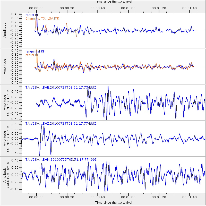
Signal To Noise
| Channel | StoN | STA | LTA |
| TA:V28A: :BHZ:20100725T03:51:17.77499Z | 11.945988 | 8.010987E-7 | 6.7060064E-8 |
| TA:V28A: :BHN:20100725T03:51:17.77499Z | 2.2763097 | 1.6990168E-7 | 7.46391E-8 |
| TA:V28A: :BHE:20100725T03:51:17.77499Z | 3.179702 | 2.733692E-7 | 8.597322E-8 |
| Arrivals |
| Ps | 12 SECOND |
| PpPs | 34 SECOND |
| PsPs/PpSs | 46 SECOND |


