You are here: Home > Network List > TA - USArray Transportable Network (new EarthScope stations) Stations List
> Station W28A Vega, TX, USA > Earthquake Result Viewer
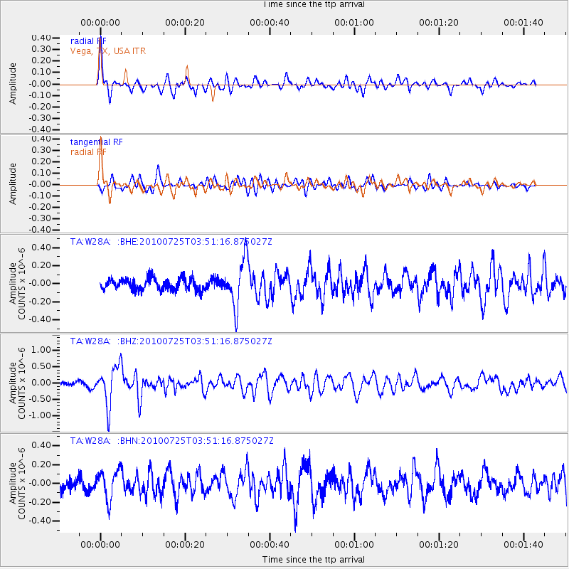
W28A Vega, TX, USA - Earthquake Result Viewer
*The percent match for this event was below the threshold and hence no stack was calculated.
| Earthquake location: |
Tonga Islands |
| Earthquake latitude/longitude: |
-15.1/-173.5 |
| Earthquake time(UTC): |
2010/07/25 (206) 03:39:17 GMT |
| Earthquake Depth: |
7.0 km |
| Earthquake Magnitude: |
5.6 MB, 5.7 MS, 5.9 MW, 5.9 MW |
| Earthquake Catalog/Contributor: |
WHDF/NEIC |
|
| Network: |
TA USArray Transportable Network (new EarthScope stations) |
| Station: |
W28A Vega, TX, USA |
| Lat/Lon: |
35.26 N/102.21 W |
| Elevation: |
1156 m |
|
| Distance: |
84.0 deg |
| Az: |
51.228 deg |
| Baz: |
246.972 deg |
| Ray Param: |
$rayparam |
*The percent match for this event was below the threshold and hence was not used in the summary stack. |
|
| Radial Match: |
77.61944 % |
| Radial Bump: |
374 |
| Transverse Match: |
65.51168 % |
| Transverse Bump: |
400 |
| SOD ConfigId: |
319893 |
| Insert Time: |
2011-01-05 10:56:26.696 +0000 |
| GWidth: |
2.5 |
| Max Bumps: |
400 |
| Tol: |
0.001 |
|
Signal To Noise
| Channel | StoN | STA | LTA |
| TA:W28A: :BHZ:20100725T03:51:16.875027Z | 6.3775177 | 6.0885156E-7 | 9.546842E-8 |
| TA:W28A: :BHN:20100725T03:51:16.875027Z | 2.135432 | 1.5849093E-7 | 7.4219614E-8 |
| TA:W28A: :BHE:20100725T03:51:16.875027Z | 4.102642 | 2.6556336E-7 | 6.472984E-8 |
| Arrivals |
| Ps | |
| PpPs | |
| PsPs/PpSs | |


