You are here: Home > Network List > TA - USArray Transportable Network (new EarthScope stations) Stations List
> Station X28A Dimmitt, TX, USA > Earthquake Result Viewer
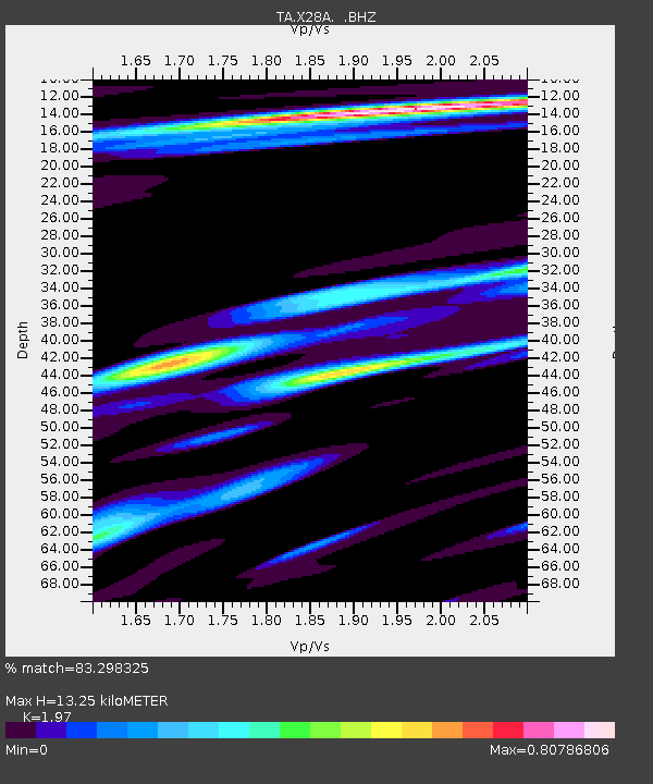
X28A Dimmitt, TX, USA - Earthquake Result Viewer
| Earthquake location: |
Tonga Islands |
| Earthquake latitude/longitude: |
-15.1/-173.5 |
| Earthquake time(UTC): |
2010/07/25 (206) 03:39:17 GMT |
| Earthquake Depth: |
7.0 km |
| Earthquake Magnitude: |
5.6 MB, 5.7 MS, 5.9 MW, 5.9 MW |
| Earthquake Catalog/Contributor: |
WHDF/NEIC |
|
| Network: |
TA USArray Transportable Network (new EarthScope stations) |
| Station: |
X28A Dimmitt, TX, USA |
| Lat/Lon: |
34.52 N/102.20 W |
| Elevation: |
1160 m |
|
| Distance: |
83.7 deg |
| Az: |
51.913 deg |
| Baz: |
247.05 deg |
| Ray Param: |
0.045990795 |
| Estimated Moho Depth: |
13.25 km |
| Estimated Crust Vp/Vs: |
1.97 |
| Assumed Crust Vp: |
6.242 km/s |
| Estimated Crust Vs: |
3.169 km/s |
| Estimated Crust Poisson's Ratio: |
0.33 |
|
| Radial Match: |
83.298325 % |
| Radial Bump: |
399 |
| Transverse Match: |
77.64628 % |
| Transverse Bump: |
384 |
| SOD ConfigId: |
319893 |
| Insert Time: |
2011-01-05 10:56:38.929 +0000 |
| GWidth: |
2.5 |
| Max Bumps: |
400 |
| Tol: |
0.001 |
|

Signal To Noise
| Channel | StoN | STA | LTA |
| TA:X28A: :BHZ:20100725T03:51:15.449978Z | 17.51909 | 1.005508E-6 | 5.739499E-8 |
| TA:X28A: :BHN:20100725T03:51:15.449978Z | 1.227623 | 7.966606E-8 | 6.4894564E-8 |
| TA:X28A: :BHE:20100725T03:51:15.449978Z | 2.7810225 | 2.934147E-7 | 1.05506054E-7 |
| Arrivals |
| Ps | 2.1 SECOND |
| PpPs | 6.2 SECOND |
| PsPs/PpSs | 8.3 SECOND |


