You are here: Home > Network List > TM - Thai Seismic Monitoring Network Stations List
> Station LOEI Nam Man, Loei > Earthquake Result Viewer
LOEI Nam Man, Loei - Earthquake Result Viewer
| Earthquake location: |
Northwestern Afghanistan |
| Earthquake latitude/longitude: |
34.6/61.9 |
| Earthquake time(UTC): |
2023/10/07 (280) 06:41:02 GMT |
| Earthquake Depth: |
10 km |
| Earthquake Magnitude: |
6.2 mww |
| Earthquake Catalog/Contributor: |
NEIC PDE/us |
|
| Network: |
TM Thai Seismic Monitoring Network |
| Station: |
LOEI Nam Man, Loei |
| Lat/Lon: |
17.51 N/101.62 E |
| Elevation: |
305 m |
|
| Distance: |
39.2 deg |
| Az: |
105.471 deg |
| Baz: |
303.604 deg |
| Ray Param: |
0.07512296 |
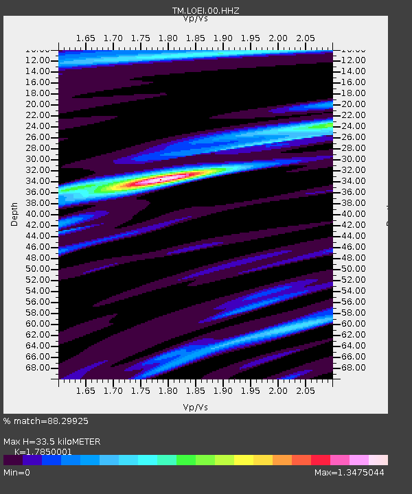
| Estimated Moho Depth: |
33.5 km |
| Estimated Crust Vp/Vs: |
1.79 |
| Assumed Crust Vp: |
6.35 km/s |
| Estimated Crust Vs: |
3.557 km/s |
| Estimated Crust Poisson's Ratio: |
0.27 |
|
| Radial Match: |
88.29925 % |
| Radial Bump: |
256 |
| Transverse Match: |
79.18911 % |
| Transverse Bump: |
400 |
| SOD ConfigId: |
31937991 |
| Insert Time: |
2023-10-21 07:15:24.483 +0000 |
| GWidth: |
2.5 |
| Max Bumps: |
400 |
| Tol: |
0.001 |
|

Signal To Noise
| Channel | StoN | STA | LTA |
| TM:LOEI:00:HHZ:20231007T06:48:00.379988Z | 14.403862 | 1.2184001E-6 | 8.4588436E-8 |
| TM:LOEI:00:HHN:20231007T06:48:00.379988Z | 4.077338 | 3.3317355E-7 | 8.1713495E-8 |
| TM:LOEI:00:HHE:20231007T06:48:00.379988Z | 9.418369 | 8.081926E-7 | 8.581026E-8 |
| Arrivals |
| Ps | 4.4 SECOND |
| PpPs | 14 SECOND |
| PsPs/PpSs | 18 SECOND |


