You are here: Home > Network List > TA - USArray Transportable Network (new EarthScope stations) Stations List
> Station 529A Stev Forest Ranch, Sanderson, TX, USA > Earthquake Result Viewer
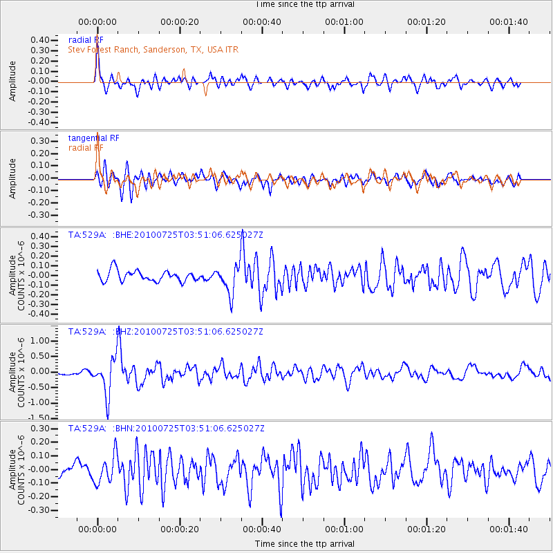
529A Stev Forest Ranch, Sanderson, TX, USA - Earthquake Result Viewer
| Earthquake location: |
Tonga Islands |
| Earthquake latitude/longitude: |
-15.1/-173.5 |
| Earthquake time(UTC): |
2010/07/25 (206) 03:39:17 GMT |
| Earthquake Depth: |
7.0 km |
| Earthquake Magnitude: |
5.6 MB, 5.7 MS, 5.9 MW, 5.9 MW |
| Earthquake Catalog/Contributor: |
WHDF/NEIC |
|
| Network: |
TA USArray Transportable Network (new EarthScope stations) |
| Station: |
529A Stev Forest Ranch, Sanderson, TX, USA |
| Lat/Lon: |
30.12 N/102.22 W |
| Elevation: |
764 m |
|
| Distance: |
82.0 deg |
| Az: |
55.979 deg |
| Baz: |
247.543 deg |
| Ray Param: |
0.047188014 |
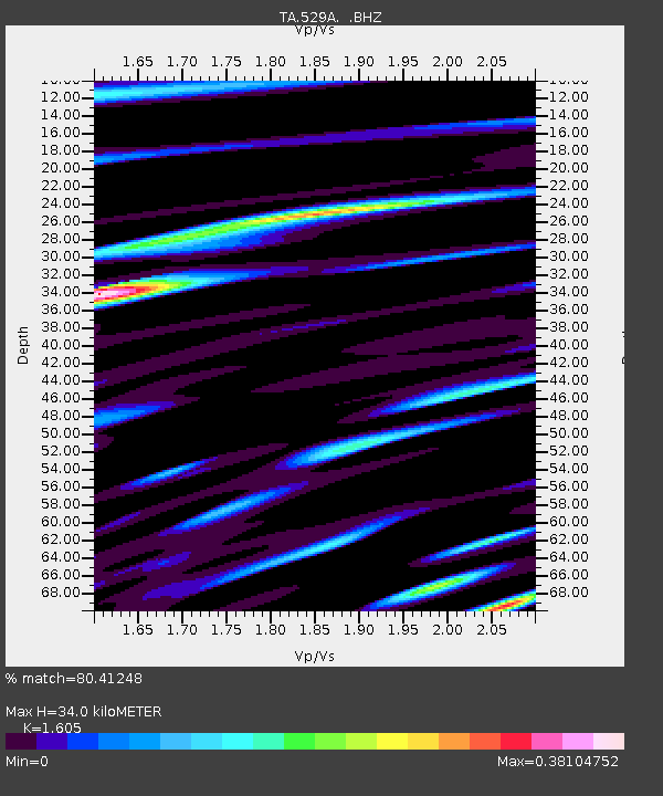
| Estimated Moho Depth: |
34.0 km |
| Estimated Crust Vp/Vs: |
1.61 |
| Assumed Crust Vp: |
6.121 km/s |
| Estimated Crust Vs: |
3.813 km/s |
| Estimated Crust Poisson's Ratio: |
0.18 |
|
| Radial Match: |
80.41248 % |
| Radial Bump: |
400 |
| Transverse Match: |
70.80108 % |
| Transverse Bump: |
400 |
| SOD ConfigId: |
319893 |
| Insert Time: |
2011-01-05 10:57:47.789 +0000 |
| GWidth: |
2.5 |
| Max Bumps: |
400 |
| Tol: |
0.001 |
|
Signal To Noise
| Channel | StoN | STA | LTA |
| TA:529A: :BHZ:20100725T03:51:06.625027Z | 8.523714 | 6.0870576E-7 | 7.1413204E-8 |
| TA:529A: :BHN:20100725T03:51:06.625027Z | 2.2964587 | 1.0530385E-7 | 4.5854883E-8 |
| TA:529A: :BHE:20100725T03:51:06.625027Z | 2.8074627 | 1.5531091E-7 | 5.532074E-8 |
| Arrivals |
| Ps | 3.5 SECOND |
| PpPs | 14 SECOND |
| PsPs/PpSs | 18 SECOND |


