You are here: Home > Network List > TA - USArray Transportable Network (new EarthScope stations) Stations List
> Station 429A Davenport Ranch, Sheffield, TX, USA > Earthquake Result Viewer
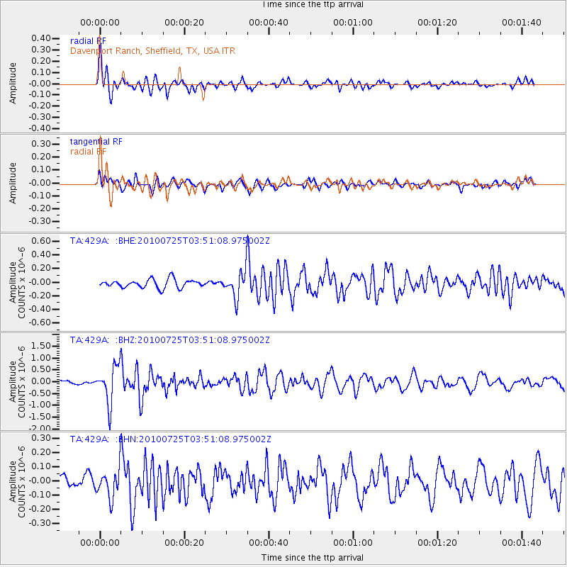
429A Davenport Ranch, Sheffield, TX, USA - Earthquake Result Viewer
| Earthquake location: |
Tonga Islands |
| Earthquake latitude/longitude: |
-15.1/-173.5 |
| Earthquake time(UTC): |
2010/07/25 (206) 03:39:17 GMT |
| Earthquake Depth: |
7.0 km |
| Earthquake Magnitude: |
5.6 MB, 5.7 MS, 5.9 MW, 5.9 MW |
| Earthquake Catalog/Contributor: |
WHDF/NEIC |
|
| Network: |
TA USArray Transportable Network (new EarthScope stations) |
| Station: |
429A Davenport Ranch, Sheffield, TX, USA |
| Lat/Lon: |
30.62 N/101.89 W |
| Elevation: |
804 m |
|
| Distance: |
82.5 deg |
| Az: |
55.622 deg |
| Baz: |
247.659 deg |
| Ray Param: |
0.046874646 |
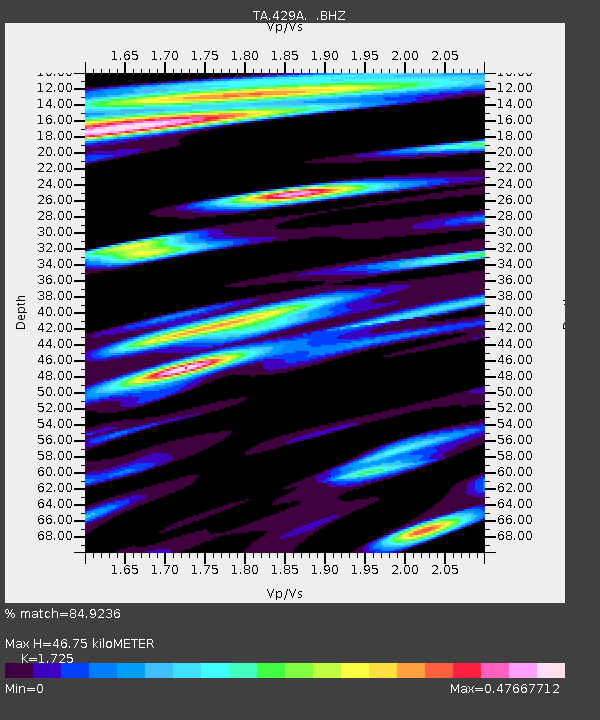
| Estimated Moho Depth: |
46.75 km |
| Estimated Crust Vp/Vs: |
1.73 |
| Assumed Crust Vp: |
6.38 km/s |
| Estimated Crust Vs: |
3.699 km/s |
| Estimated Crust Poisson's Ratio: |
0.25 |
|
| Radial Match: |
84.9236 % |
| Radial Bump: |
393 |
| Transverse Match: |
54.929123 % |
| Transverse Bump: |
394 |
| SOD ConfigId: |
319893 |
| Insert Time: |
2011-01-05 10:57:51.459 +0000 |
| GWidth: |
2.5 |
| Max Bumps: |
400 |
| Tol: |
0.001 |
|
Signal To Noise
| Channel | StoN | STA | LTA |
| TA:429A: :BHZ:20100725T03:51:08.975002Z | 7.9229383 | 8.144027E-7 | 1.0279049E-7 |
| TA:429A: :BHN:20100725T03:51:08.975002Z | 2.1310287 | 1.04449725E-7 | 4.9013757E-8 |
| TA:429A: :BHE:20100725T03:51:08.975002Z | 3.3022377 | 2.0409225E-7 | 6.180422E-8 |
| Arrivals |
| Ps | 5.5 SECOND |
| PpPs | 19 SECOND |
| PsPs/PpSs | 25 SECOND |


