You are here: Home > Network List > TA - USArray Transportable Network (new EarthScope stations) Stations List
> Station 331A San Angelo, TX, USA > Earthquake Result Viewer
331A San Angelo, TX, USA - Earthquake Result Viewer
| Earthquake location: |
Tonga Islands |
| Earthquake latitude/longitude: |
-15.1/-173.5 |
| Earthquake time(UTC): |
2010/07/25 (206) 03:39:17 GMT |
| Earthquake Depth: |
7.0 km |
| Earthquake Magnitude: |
5.6 MB, 5.7 MS, 5.9 MW, 5.9 MW |
| Earthquake Catalog/Contributor: |
WHDF/NEIC |
|
| Network: |
TA USArray Transportable Network (new EarthScope stations) |
| Station: |
331A San Angelo, TX, USA |
| Lat/Lon: |
31.31 N/100.43 W |
| Elevation: |
615 m |
|
| Distance: |
83.9 deg |
| Az: |
55.461 deg |
| Baz: |
248.391 deg |
| Ray Param: |
0.045873195 |
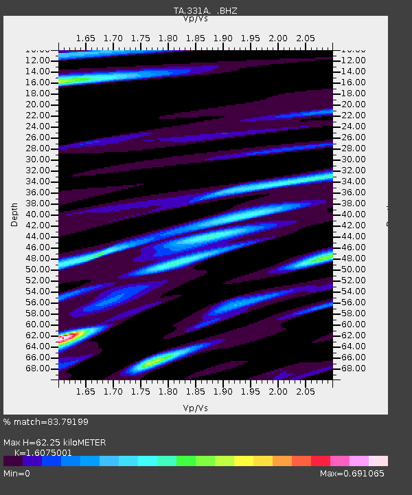
| Estimated Moho Depth: |
62.25 km |
| Estimated Crust Vp/Vs: |
1.61 |
| Assumed Crust Vp: |
6.38 km/s |
| Estimated Crust Vs: |
3.969 km/s |
| Estimated Crust Poisson's Ratio: |
0.18 |
|
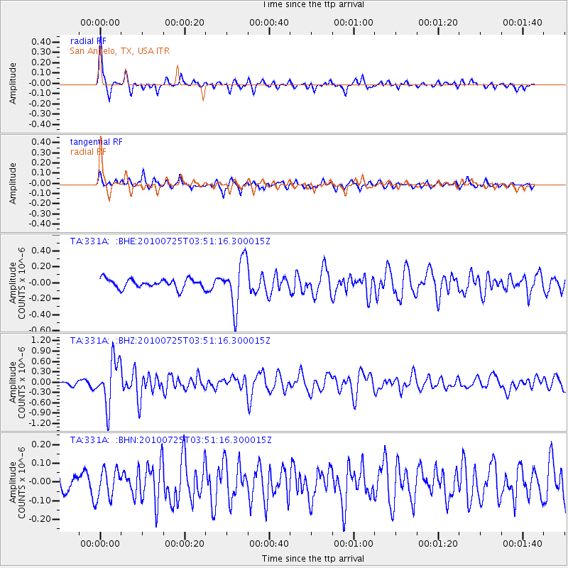
| Radial Match: |
83.79199 % |
| Radial Bump: |
323 |
| Transverse Match: |
62.301823 % |
| Transverse Bump: |
358 |
| SOD ConfigId: |
319893 |
| Insert Time: |
2011-01-05 10:59:11.901 +0000 |
| GWidth: |
2.5 |
| Max Bumps: |
400 |
| Tol: |
0.001 |
|
Signal To Noise
| Channel | StoN | STA | LTA |
| TA:331A: :BHZ:20100725T03:51:16.300015Z | 11.028573 | 6.751438E-7 | 6.121769E-8 |
| TA:331A: :BHN:20100725T03:51:16.300015Z | 1.7576061 | 7.3967556E-8 | 4.208426E-8 |
| TA:331A: :BHE:20100725T03:51:16.300015Z | 5.3082824 | 3.0676338E-7 | 5.7789578E-8 |
| Arrivals |
| Ps | 6.1 SECOND |
| PpPs | 25 SECOND |
| PsPs/PpSs | 31 SECOND |


