You are here: Home > Network List > AK - Alaska Regional Network Stations List
> Station I27K Kandik River, AK, USA > Earthquake Result Viewer
I27K Kandik River, AK, USA - Earthquake Result Viewer
| Earthquake location: |
Northwestern Afghanistan |
| Earthquake latitude/longitude: |
34.5/61.9 |
| Earthquake time(UTC): |
2023/10/07 (280) 07:12:50 GMT |
| Earthquake Depth: |
11 km |
| Earthquake Magnitude: |
6.2 mww |
| Earthquake Catalog/Contributor: |
NEIC PDE/us |
|
| Network: |
AK Alaska Regional Network |
| Station: |
I27K Kandik River, AK, USA |
| Lat/Lon: |
65.60 N/141.62 W |
| Elevation: |
874 m |
|
| Distance: |
78.5 deg |
| Az: |
9.73 deg |
| Baz: |
340.376 deg |
| Ray Param: |
0.049590837 |
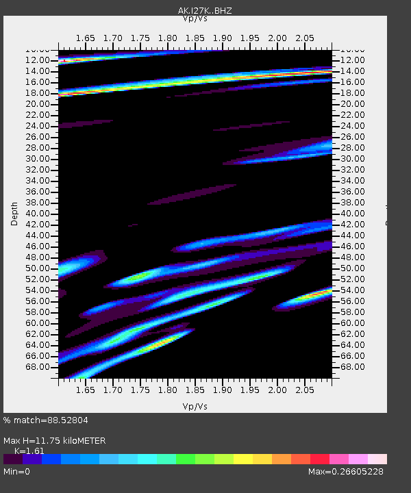
| Estimated Moho Depth: |
11.75 km |
| Estimated Crust Vp/Vs: |
1.61 |
| Assumed Crust Vp: |
6.566 km/s |
| Estimated Crust Vs: |
4.078 km/s |
| Estimated Crust Poisson's Ratio: |
0.19 |
|
| Radial Match: |
88.52804 % |
| Radial Bump: |
326 |
| Transverse Match: |
54.637123 % |
| Transverse Bump: |
278 |
| SOD ConfigId: |
31937991 |
| Insert Time: |
2023-10-21 07:46:43.225 +0000 |
| GWidth: |
2.5 |
| Max Bumps: |
400 |
| Tol: |
0.001 |
|

Signal To Noise
| Channel | StoN | STA | LTA |
| AK:I27K: :BHZ:20231007T07:24:20.020018Z | 1.8239125 | 3.2347236E-6 | 1.7735082E-6 |
| AK:I27K: :BHN:20231007T07:24:20.020018Z | 1.5774775 | 1.7771591E-6 | 1.1265829E-6 |
| AK:I27K: :BHE:20231007T07:24:20.020018Z | 1.5324593 | 1.0442533E-6 | 6.814232E-7 |
| Arrivals |
| Ps | 1.1 SECOND |
| PpPs | 4.5 SECOND |
| PsPs/PpSs | 5.6 SECOND |


