You are here: Home > Network List > TA - USArray Transportable Network (new EarthScope stations) Stations List
> Station S28A Manter, KS, USA > Earthquake Result Viewer
S28A Manter, KS, USA - Earthquake Result Viewer
| Earthquake location: |
Tonga Islands |
| Earthquake latitude/longitude: |
-15.1/-173.5 |
| Earthquake time(UTC): |
2010/07/25 (206) 03:39:17 GMT |
| Earthquake Depth: |
7.0 km |
| Earthquake Magnitude: |
5.6 MB, 5.7 MS, 5.9 MW, 5.9 MW |
| Earthquake Catalog/Contributor: |
WHDF/NEIC |
|
| Network: |
TA USArray Transportable Network (new EarthScope stations) |
| Station: |
S28A Manter, KS, USA |
| Lat/Lon: |
37.59 N/101.90 W |
| Elevation: |
1064 m |
|
| Distance: |
85.1 deg |
| Az: |
49.174 deg |
| Baz: |
246.96 deg |
| Ray Param: |
0.044981103 |
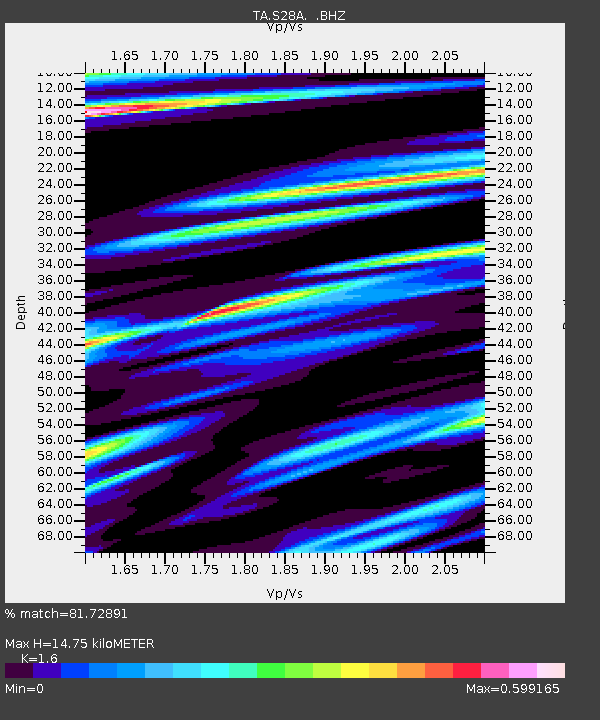
| Estimated Moho Depth: |
14.75 km |
| Estimated Crust Vp/Vs: |
1.60 |
| Assumed Crust Vp: |
6.483 km/s |
| Estimated Crust Vs: |
4.052 km/s |
| Estimated Crust Poisson's Ratio: |
0.18 |
|
| Radial Match: |
81.72891 % |
| Radial Bump: |
326 |
| Transverse Match: |
60.189976 % |
| Transverse Bump: |
306 |
| SOD ConfigId: |
319893 |
| Insert Time: |
2011-01-05 11:00:53.997 +0000 |
| GWidth: |
2.5 |
| Max Bumps: |
400 |
| Tol: |
0.001 |
|

Signal To Noise
| Channel | StoN | STA | LTA |
| TA:S28A: :BHZ:20100725T03:51:22.625027Z | 10.268631 | 6.860343E-7 | 6.680874E-8 |
| TA:S28A: :BHN:20100725T03:51:22.625027Z | 1.9386805 | 1.7445441E-7 | 8.998616E-8 |
| TA:S28A: :BHE:20100725T03:51:22.625027Z | 3.7797453 | 3.065797E-7 | 8.11112E-8 |
| Arrivals |
| Ps | 1.4 SECOND |
| PpPs | 5.8 SECOND |
| PsPs/PpSs | 7.2 SECOND |


