You are here: Home > Network List > TA - USArray Transportable Network (new EarthScope stations) Stations List
> Station R28A Tribune, KS, USA > Earthquake Result Viewer
R28A Tribune, KS, USA - Earthquake Result Viewer
| Earthquake location: |
Tonga Islands |
| Earthquake latitude/longitude: |
-15.1/-173.5 |
| Earthquake time(UTC): |
2010/07/25 (206) 03:39:17 GMT |
| Earthquake Depth: |
7.0 km |
| Earthquake Magnitude: |
5.6 MB, 5.7 MS, 5.9 MW, 5.9 MW |
| Earthquake Catalog/Contributor: |
WHDF/NEIC |
|
| Network: |
TA USArray Transportable Network (new EarthScope stations) |
| Station: |
R28A Tribune, KS, USA |
| Lat/Lon: |
38.34 N/101.81 W |
| Elevation: |
1108 m |
|
| Distance: |
85.5 deg |
| Az: |
48.507 deg |
| Baz: |
246.959 deg |
| Ray Param: |
0.044724222 |
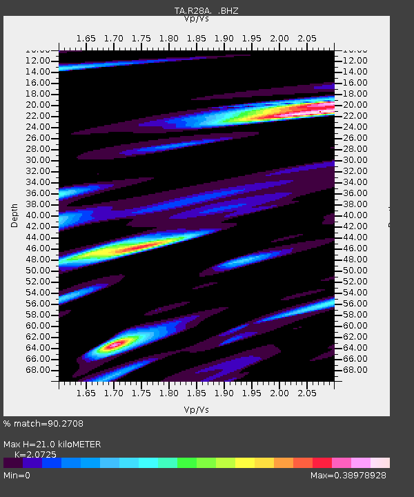
| Estimated Moho Depth: |
21.0 km |
| Estimated Crust Vp/Vs: |
2.07 |
| Assumed Crust Vp: |
6.483 km/s |
| Estimated Crust Vs: |
3.128 km/s |
| Estimated Crust Poisson's Ratio: |
0.35 |
|
| Radial Match: |
90.2708 % |
| Radial Bump: |
317 |
| Transverse Match: |
76.54101 % |
| Transverse Bump: |
394 |
| SOD ConfigId: |
319893 |
| Insert Time: |
2011-01-05 11:01:01.714 +0000 |
| GWidth: |
2.5 |
| Max Bumps: |
400 |
| Tol: |
0.001 |
|
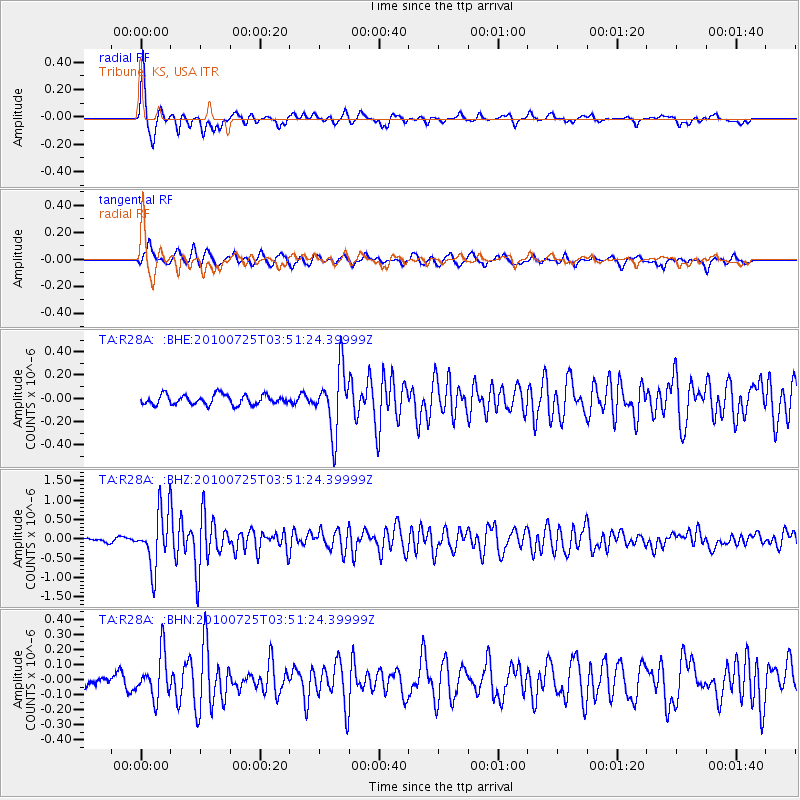
Signal To Noise
| Channel | StoN | STA | LTA |
| TA:R28A: :BHZ:20100725T03:51:24.39999Z | 16.01831 | 7.1457634E-7 | 4.460997E-8 |
| TA:R28A: :BHN:20100725T03:51:24.39999Z | 2.9790077 | 1.4694506E-7 | 4.9326843E-8 |
| TA:R28A: :BHE:20100725T03:51:24.39999Z | 6.256397 | 2.6348047E-7 | 4.2113772E-8 |
| Arrivals |
| Ps | 3.5 SECOND |
| PpPs | 9.7 SECOND |
| PsPs/PpSs | 13 SECOND |


