You are here: Home > Network List > TA - USArray Transportable Network (new EarthScope stations) Stations List
> Station V27A Dan Oppilter Farms, Dalhart, TX, USA > Earthquake Result Viewer
V27A Dan Oppilter Farms, Dalhart, TX, USA - Earthquake Result Viewer
| Earthquake location: |
Tonga Islands |
| Earthquake latitude/longitude: |
-15.1/-173.5 |
| Earthquake time(UTC): |
2010/07/25 (206) 03:39:17 GMT |
| Earthquake Depth: |
7.0 km |
| Earthquake Magnitude: |
5.6 MB, 5.7 MS, 5.9 MW, 5.9 MW |
| Earthquake Catalog/Contributor: |
WHDF/NEIC |
|
| Network: |
TA USArray Transportable Network (new EarthScope stations) |
| Station: |
V27A Dan Oppilter Farms, Dalhart, TX, USA |
| Lat/Lon: |
35.76 N/102.84 W |
| Elevation: |
1228 m |
|
| Distance: |
83.7 deg |
| Az: |
50.563 deg |
| Baz: |
246.537 deg |
| Ray Param: |
0.04598675 |
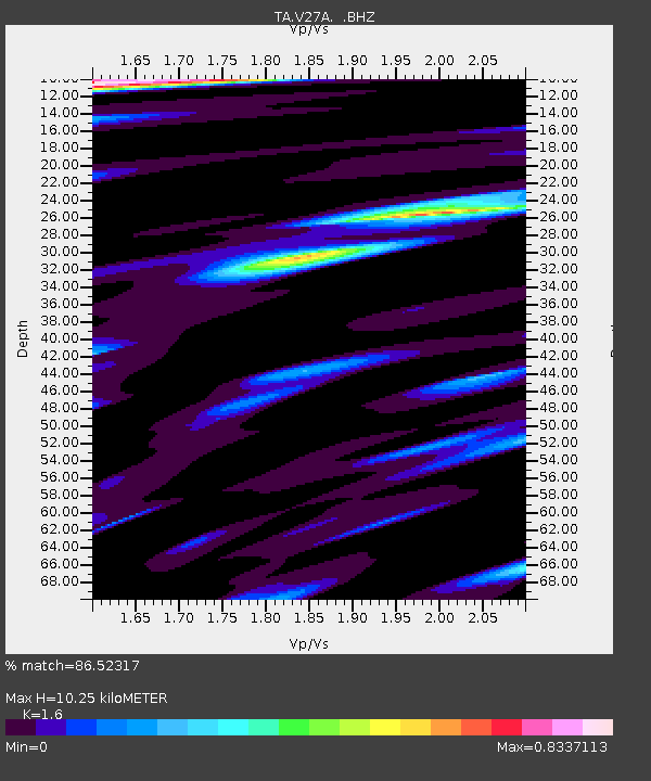
| Estimated Moho Depth: |
10.25 km |
| Estimated Crust Vp/Vs: |
1.60 |
| Assumed Crust Vp: |
6.242 km/s |
| Estimated Crust Vs: |
3.901 km/s |
| Estimated Crust Poisson's Ratio: |
0.18 |
|
| Radial Match: |
86.52317 % |
| Radial Bump: |
335 |
| Transverse Match: |
73.0674 % |
| Transverse Bump: |
388 |
| SOD ConfigId: |
319893 |
| Insert Time: |
2011-01-05 11:01:05.199 +0000 |
| GWidth: |
2.5 |
| Max Bumps: |
400 |
| Tol: |
0.001 |
|
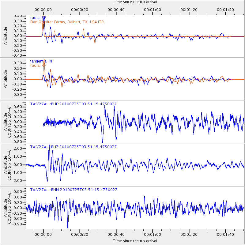
Signal To Noise
| Channel | StoN | STA | LTA |
| TA:V27A: :BHZ:20100725T03:51:15.475002Z | 17.764833 | 1.0604592E-6 | 5.9694294E-8 |
| TA:V27A: :BHN:20100725T03:51:15.475002Z | 1.339111 | 1.7138125E-7 | 1.2798135E-7 |
| TA:V27A: :BHE:20100725T03:51:15.475002Z | 4.2398844 | 3.5279996E-7 | 8.3209805E-8 |
| Arrivals |
| Ps | 1.0 SECOND |
| PpPs | 4.2 SECOND |
| PsPs/PpSs | 5.2 SECOND |


