You are here: Home > Network List > TA - USArray Transportable Network (new EarthScope stations) Stations List
> Station U27A Thompson Grove, Rita Blanca Nat Grassland, TX, USA > Earthquake Result Viewer
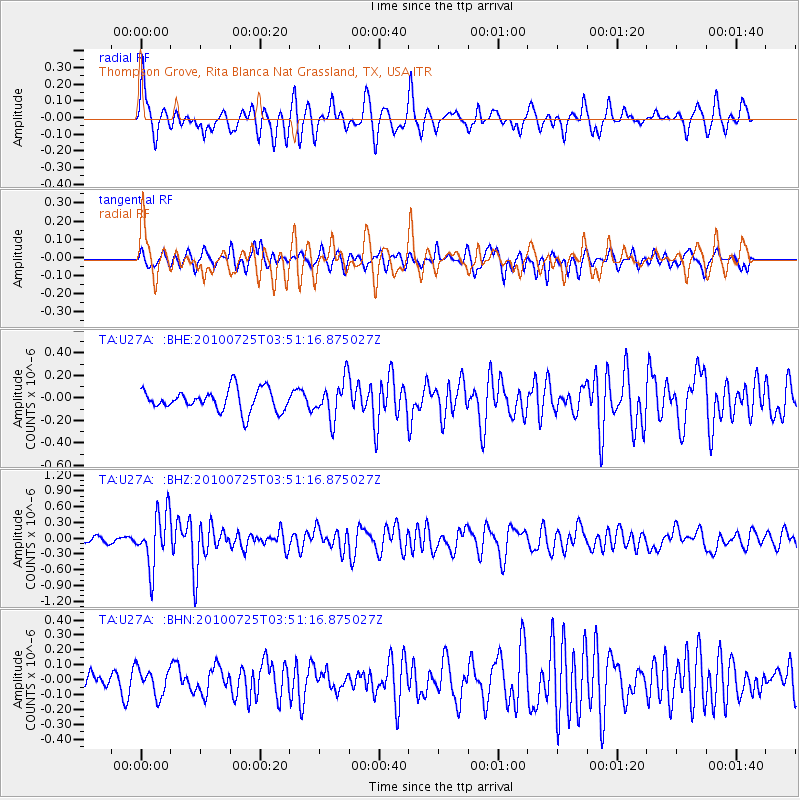
U27A Thompson Grove, Rita Blanca Nat Grassland, TX, USA - Earthquake Result Viewer
*The percent match for this event was below the threshold and hence no stack was calculated.
| Earthquake location: |
Tonga Islands |
| Earthquake latitude/longitude: |
-15.1/-173.5 |
| Earthquake time(UTC): |
2010/07/25 (206) 03:39:17 GMT |
| Earthquake Depth: |
7.0 km |
| Earthquake Magnitude: |
5.6 MB, 5.7 MS, 5.9 MW, 5.9 MW |
| Earthquake Catalog/Contributor: |
WHDF/NEIC |
|
| Network: |
TA USArray Transportable Network (new EarthScope stations) |
| Station: |
U27A Thompson Grove, Rita Blanca Nat Grassland, TX, USA |
| Lat/Lon: |
36.42 N/102.82 W |
| Elevation: |
1342 m |
|
| Distance: |
84.0 deg |
| Az: |
49.955 deg |
| Baz: |
246.478 deg |
| Ray Param: |
$rayparam |
*The percent match for this event was below the threshold and hence was not used in the summary stack. |
|
| Radial Match: |
66.01493 % |
| Radial Bump: |
360 |
| Transverse Match: |
68.2957 % |
| Transverse Bump: |
376 |
| SOD ConfigId: |
319893 |
| Insert Time: |
2011-01-05 11:01:25.423 +0000 |
| GWidth: |
2.5 |
| Max Bumps: |
400 |
| Tol: |
0.001 |
|
Signal To Noise
| Channel | StoN | STA | LTA |
| TA:U27A: :BHZ:20100725T03:51:16.875027Z | 6.835582 | 5.121516E-7 | 7.492436E-8 |
| TA:U27A: :BHN:20100725T03:51:16.875027Z | 1.3440393 | 8.960552E-8 | 6.6668825E-8 |
| TA:U27A: :BHE:20100725T03:51:16.875027Z | 1.7675624 | 1.7040581E-7 | 9.640724E-8 |
| Arrivals |
| Ps | |
| PpPs | |
| PsPs/PpSs | |


