You are here: Home > Network List > TA - USArray Transportable Network (new EarthScope stations) Stations List
> Station R30A Dighton, KS, USA > Earthquake Result Viewer
R30A Dighton, KS, USA - Earthquake Result Viewer
| Earthquake location: |
Tonga Islands |
| Earthquake latitude/longitude: |
-15.1/-173.5 |
| Earthquake time(UTC): |
2010/07/25 (206) 03:39:17 GMT |
| Earthquake Depth: |
7.0 km |
| Earthquake Magnitude: |
5.6 MB, 5.7 MS, 5.9 MW, 5.9 MW |
| Earthquake Catalog/Contributor: |
WHDF/NEIC |
|
| Network: |
TA USArray Transportable Network (new EarthScope stations) |
| Station: |
R30A Dighton, KS, USA |
| Lat/Lon: |
38.28 N/100.28 W |
| Elevation: |
776 m |
|
| Distance: |
86.6 deg |
| Az: |
49.025 deg |
| Baz: |
247.942 deg |
| Ray Param: |
0.043944664 |
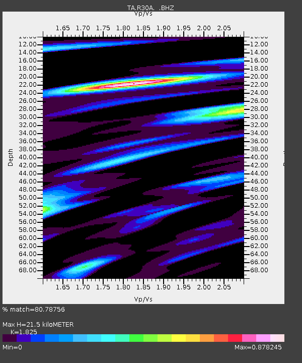
| Estimated Moho Depth: |
21.5 km |
| Estimated Crust Vp/Vs: |
1.83 |
| Assumed Crust Vp: |
6.483 km/s |
| Estimated Crust Vs: |
3.552 km/s |
| Estimated Crust Poisson's Ratio: |
0.29 |
|
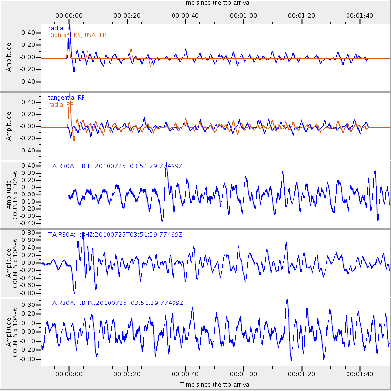
| Radial Match: |
80.78756 % |
| Radial Bump: |
320 |
| Transverse Match: |
57.333763 % |
| Transverse Bump: |
316 |
| SOD ConfigId: |
319893 |
| Insert Time: |
2011-01-05 11:01:27.407 +0000 |
| GWidth: |
2.5 |
| Max Bumps: |
400 |
| Tol: |
0.001 |
|
Signal To Noise
| Channel | StoN | STA | LTA |
| TA:R30A: :BHZ:20100725T03:51:29.77499Z | 9.180391 | 4.1542393E-7 | 4.525122E-8 |
| TA:R30A: :BHN:20100725T03:51:29.77499Z | 0.93951356 | 7.593146E-8 | 8.081997E-8 |
| TA:R30A: :BHE:20100725T03:51:29.77499Z | 3.0646827 | 2.093061E-7 | 6.829617E-8 |
| Arrivals |
| Ps | 2.8 SECOND |
| PpPs | 9.2 SECOND |
| PsPs/PpSs | 12 SECOND |


