You are here: Home > Network List > TA - USArray Transportable Network (new EarthScope stations) Stations List
> Station Q30A Quinter, KS, USA > Earthquake Result Viewer
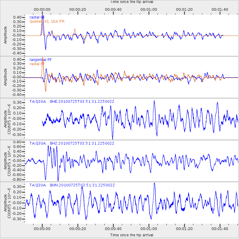
Q30A Quinter, KS, USA - Earthquake Result Viewer
*The percent match for this event was below the threshold and hence no stack was calculated.
| Earthquake location: |
Tonga Islands |
| Earthquake latitude/longitude: |
-15.1/-173.5 |
| Earthquake time(UTC): |
2010/07/25 (206) 03:39:17 GMT |
| Earthquake Depth: |
7.0 km |
| Earthquake Magnitude: |
5.6 MB, 5.7 MS, 5.9 MW, 5.9 MW |
| Earthquake Catalog/Contributor: |
WHDF/NEIC |
|
| Network: |
TA USArray Transportable Network (new EarthScope stations) |
| Station: |
Q30A Quinter, KS, USA |
| Lat/Lon: |
38.98 N/100.22 W |
| Elevation: |
797 m |
|
| Distance: |
86.9 deg |
| Az: |
48.399 deg |
| Baz: |
247.941 deg |
| Ray Param: |
$rayparam |
*The percent match for this event was below the threshold and hence was not used in the summary stack. |
|
| Radial Match: |
77.80595 % |
| Radial Bump: |
330 |
| Transverse Match: |
63.22449 % |
| Transverse Bump: |
345 |
| SOD ConfigId: |
319893 |
| Insert Time: |
2011-01-05 11:02:21.086 +0000 |
| GWidth: |
2.5 |
| Max Bumps: |
400 |
| Tol: |
0.001 |
|
Signal To Noise
| Channel | StoN | STA | LTA |
| TA:Q30A: :BHZ:20100725T03:51:31.225002Z | 4.2157497 | 3.8986641E-7 | 9.2478544E-8 |
| TA:Q30A: :BHN:20100725T03:51:31.225002Z | 1.6389039 | 1.3266144E-7 | 8.094522E-8 |
| TA:Q30A: :BHE:20100725T03:51:31.225002Z | 1.9010296 | 1.2595365E-7 | 6.625549E-8 |
| Arrivals |
| Ps | |
| PpPs | |
| PsPs/PpSs | |


