You are here: Home > Network List > TA - USArray Transportable Network (new EarthScope stations) Stations List
> Station J28A Allard Ranch, Norris, SD, USA > Earthquake Result Viewer
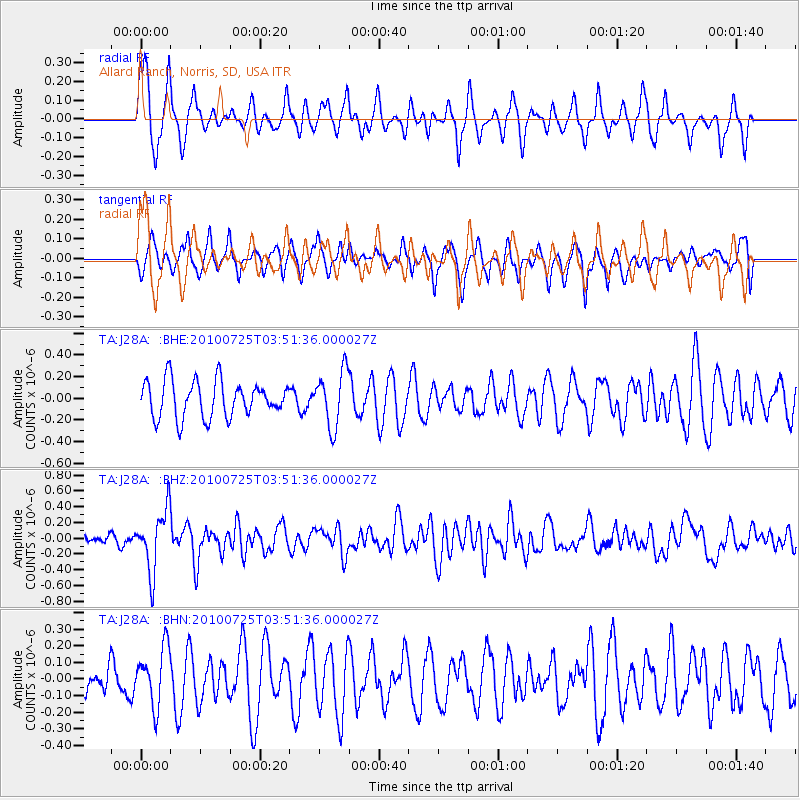
J28A Allard Ranch, Norris, SD, USA - Earthquake Result Viewer
*The percent match for this event was below the threshold and hence no stack was calculated.
| Earthquake location: |
Tonga Islands |
| Earthquake latitude/longitude: |
-15.1/-173.5 |
| Earthquake time(UTC): |
2010/07/25 (206) 03:39:17 GMT |
| Earthquake Depth: |
7.0 km |
| Earthquake Magnitude: |
5.6 MB, 5.7 MS, 5.9 MW, 5.9 MW |
| Earthquake Catalog/Contributor: |
WHDF/NEIC |
|
| Network: |
TA USArray Transportable Network (new EarthScope stations) |
| Station: |
J28A Allard Ranch, Norris, SD, USA |
| Lat/Lon: |
43.42 N/101.24 W |
| Elevation: |
835 m |
|
| Distance: |
87.9 deg |
| Az: |
43.997 deg |
| Baz: |
247.074 deg |
| Ray Param: |
$rayparam |
*The percent match for this event was below the threshold and hence was not used in the summary stack. |
|
| Radial Match: |
65.36111 % |
| Radial Bump: |
395 |
| Transverse Match: |
44.183346 % |
| Transverse Bump: |
341 |
| SOD ConfigId: |
319893 |
| Insert Time: |
2011-01-05 11:03:20.472 +0000 |
| GWidth: |
2.5 |
| Max Bumps: |
400 |
| Tol: |
0.001 |
|
Signal To Noise
| Channel | StoN | STA | LTA |
| TA:J28A: :BHZ:20100725T03:51:36.000027Z | 4.8959246 | 3.8789057E-7 | 7.9227235E-8 |
| TA:J28A: :BHN:20100725T03:51:36.000027Z | 1.7543762 | 1.7561092E-7 | 1.0009878E-7 |
| TA:J28A: :BHE:20100725T03:51:36.000027Z | 1.5419109 | 2.575428E-7 | 1.6702832E-7 |
| Arrivals |
| Ps | |
| PpPs | |
| PsPs/PpSs | |


