You are here: Home > Network List > N4 - Central and EAstern US Network Stations List
> Station G40A Rib Lake, WI, USA > Earthquake Result Viewer
G40A Rib Lake, WI, USA - Earthquake Result Viewer
| Earthquake location: |
Northwestern Afghanistan |
| Earthquake latitude/longitude: |
34.5/61.9 |
| Earthquake time(UTC): |
2023/10/07 (280) 07:12:50 GMT |
| Earthquake Depth: |
11 km |
| Earthquake Magnitude: |
6.2 mww |
| Earthquake Catalog/Contributor: |
NEIC PDE/us |
|
| Network: |
N4 Central and EAstern US Network |
| Station: |
G40A Rib Lake, WI, USA |
| Lat/Lon: |
45.27 N/90.20 W |
| Elevation: |
472 m |
|
| Distance: |
96.6 deg |
| Az: |
340.56 deg |
| Baz: |
22.894 deg |
| Ray Param: |
0.04046218 |
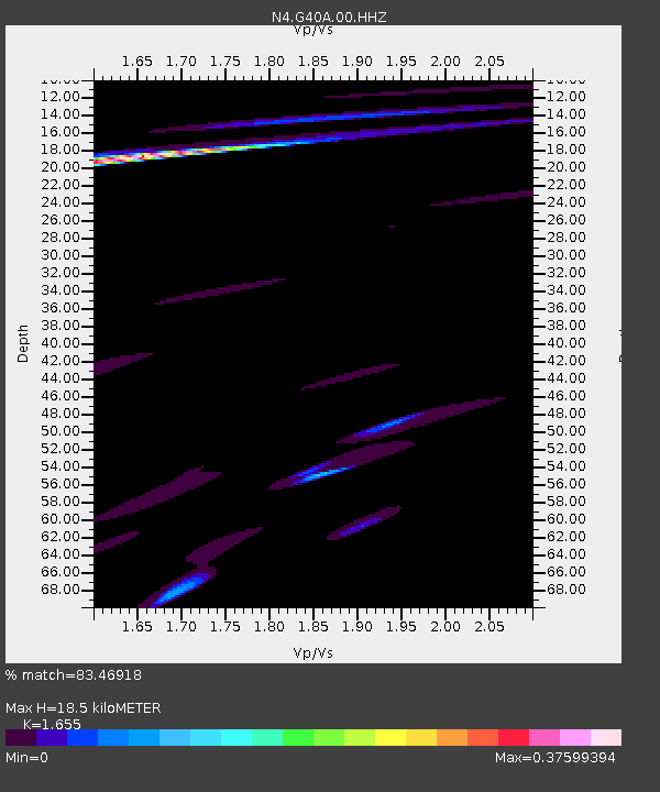
| Estimated Moho Depth: |
18.5 km |
| Estimated Crust Vp/Vs: |
1.65 |
| Assumed Crust Vp: |
6.571 km/s |
| Estimated Crust Vs: |
3.97 km/s |
| Estimated Crust Poisson's Ratio: |
0.21 |
|
| Radial Match: |
83.46918 % |
| Radial Bump: |
400 |
| Transverse Match: |
64.440155 % |
| Transverse Bump: |
400 |
| SOD ConfigId: |
31937991 |
| Insert Time: |
2023-10-21 08:07:46.070 +0000 |
| GWidth: |
2.5 |
| Max Bumps: |
400 |
| Tol: |
0.001 |
|

Signal To Noise
| Channel | StoN | STA | LTA |
| N4:G40A:00:HHZ:20231007T07:25:48.408995Z | 2.2908974 | 6.7488367E-7 | 2.9459358E-7 |
| N4:G40A:00:HH1:20231007T07:25:48.408995Z | 0.96172357 | 2.239203E-7 | 2.3283228E-7 |
| N4:G40A:00:HH2:20231007T07:25:48.408995Z | 1.235467 | 4.62379E-7 | 3.7425445E-7 |
| Arrivals |
| Ps | 1.9 SECOND |
| PpPs | 7.3 SECOND |
| PsPs/PpSs | 9.2 SECOND |


