You are here: Home > Network List > US - United States National Seismic Network Stations List
> Station AMTX Amarillo, Texas, USA > Earthquake Result Viewer
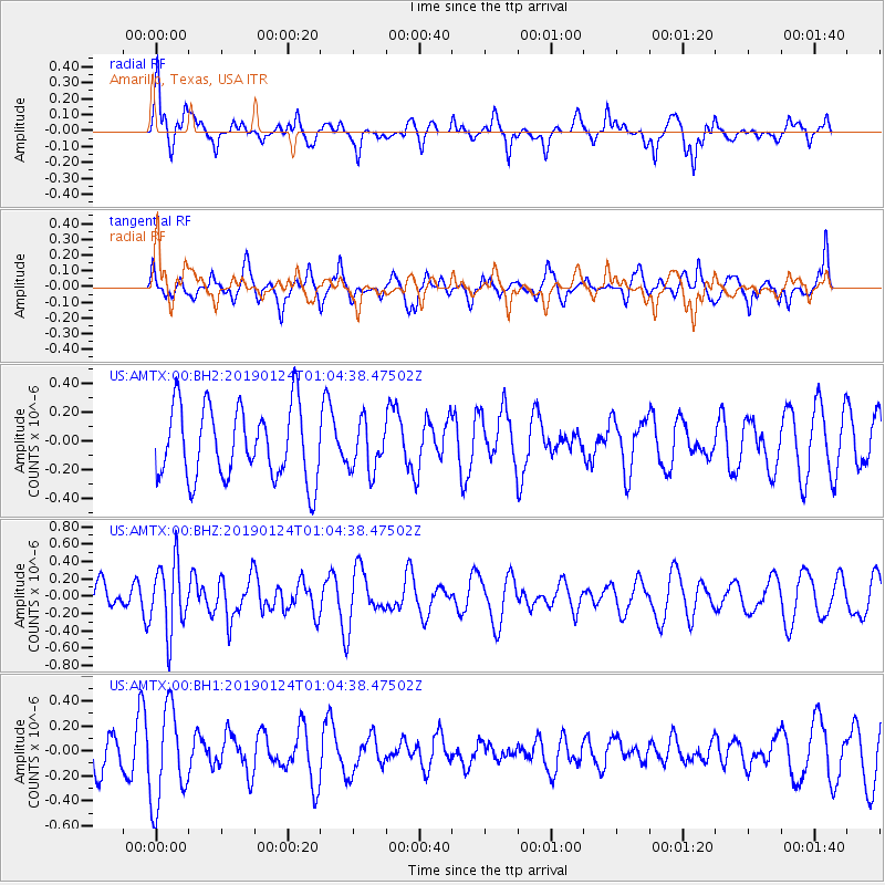
AMTX Amarillo, Texas, USA - Earthquake Result Viewer
*The percent match for this event was below the threshold and hence no stack was calculated.
| Earthquake location: |
Tonga Islands |
| Earthquake latitude/longitude: |
-15.1/-173.4 |
| Earthquake time(UTC): |
2019/01/24 (024) 00:52:38 GMT |
| Earthquake Depth: |
10 km |
| Earthquake Magnitude: |
5.5 mb |
| Earthquake Catalog/Contributor: |
NEIC PDE/us |
|
| Network: |
US United States National Seismic Network |
| Station: |
AMTX Amarillo, Texas, USA |
| Lat/Lon: |
34.53 N/101.41 W |
| Elevation: |
1010 m |
|
| Distance: |
84.3 deg |
| Az: |
52.104 deg |
| Baz: |
247.382 deg |
| Ray Param: |
$rayparam |
*The percent match for this event was below the threshold and hence was not used in the summary stack. |
|
| Radial Match: |
65.28949 % |
| Radial Bump: |
346 |
| Transverse Match: |
49.178238 % |
| Transverse Bump: |
340 |
| SOD ConfigId: |
3276131 |
| Insert Time: |
2019-02-07 00:59:42.219 +0000 |
| GWidth: |
2.5 |
| Max Bumps: |
400 |
| Tol: |
0.001 |
|
Signal To Noise
| Channel | StoN | STA | LTA |
| US:AMTX:00:BHZ:20190124T01:04:38.47502Z | 3.0853245 | 3.951224E-7 | 1.2806511E-7 |
| US:AMTX:00:BH1:20190124T01:04:38.47502Z | 1.5032853 | 3.8327565E-7 | 2.549587E-7 |
| US:AMTX:00:BH2:20190124T01:04:38.47502Z | 0.70191705 | 1.7568944E-7 | 2.5029942E-7 |
| Arrivals |
| Ps | |
| PpPs | |
| PsPs/PpSs | |


