You are here: Home > Network List > TM - Thai Seismic Monitoring Network Stations List
> Station PANO PANO staion > Earthquake Result Viewer
PANO PANO staion - Earthquake Result Viewer
| Earthquake location: |
Northwestern Afghanistan |
| Earthquake latitude/longitude: |
34.5/61.9 |
| Earthquake time(UTC): |
2023/10/07 (280) 07:12:50 GMT |
| Earthquake Depth: |
11 km |
| Earthquake Magnitude: |
6.2 mww |
| Earthquake Catalog/Contributor: |
NEIC PDE/us |
|
| Network: |
TM Thai Seismic Monitoring Network |
| Station: |
PANO PANO staion |
| Lat/Lon: |
17.15 N/104.61 E |
| Elevation: |
136 m |
|
| Distance: |
41.8 deg |
| Az: |
103.406 deg |
| Baz: |
302.882 deg |
| Ray Param: |
0.073545136 |
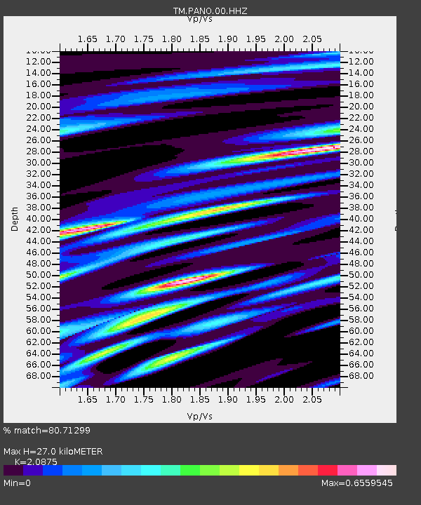
| Estimated Moho Depth: |
27.0 km |
| Estimated Crust Vp/Vs: |
2.09 |
| Assumed Crust Vp: |
6.498 km/s |
| Estimated Crust Vs: |
3.113 km/s |
| Estimated Crust Poisson's Ratio: |
0.35 |
|
| Radial Match: |
80.71299 % |
| Radial Bump: |
400 |
| Transverse Match: |
79.302444 % |
| Transverse Bump: |
400 |
| SOD ConfigId: |
31937991 |
| Insert Time: |
2023-10-21 08:13:24.962 +0000 |
| GWidth: |
2.5 |
| Max Bumps: |
400 |
| Tol: |
0.001 |
|

Signal To Noise
| Channel | StoN | STA | LTA |
| TM:PANO:00:HHZ:20231007T07:20:09.100004Z | 29.140528 | 4.845045E-7 | 1.6626483E-8 |
| TM:PANO:00:HHN:20231007T07:20:09.100004Z | 2.2012088 | 3.374035E-8 | 1.53281E-8 |
| TM:PANO:00:HHE:20231007T07:20:09.100004Z | 8.287664 | 1.5964314E-7 | 1.926274E-8 |
| Arrivals |
| Ps | 4.8 SECOND |
| PpPs | 12 SECOND |
| PsPs/PpSs | 17 SECOND |


