You are here: Home > Network List > AV - Alaska Volcano Observatory Stations List
> Station SPCL Chakachamna Lake, Mount Spurr, Alaska > Earthquake Result Viewer
SPCL Chakachamna Lake, Mount Spurr, Alaska - Earthquake Result Viewer
| Earthquake location: |
Northwestern Afghanistan |
| Earthquake latitude/longitude: |
34.6/62.0 |
| Earthquake time(UTC): |
2023/10/07 (280) 07:40:29 GMT |
| Earthquake Depth: |
7.7 km |
| Earthquake Magnitude: |
5.9 mww |
| Earthquake Catalog/Contributor: |
NEIC PDE/us |
|
| Network: |
AV Alaska Volcano Observatory |
| Station: |
SPCL Chakachamna Lake, Mount Spurr, Alaska |
| Lat/Lon: |
61.20 N/152.34 W |
| Elevation: |
1274 m |
|
| Distance: |
80.5 deg |
| Az: |
16.096 deg |
| Baz: |
331.835 deg |
| Ray Param: |
0.04825535 |
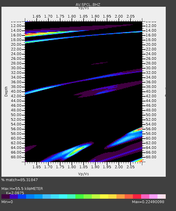
| Estimated Moho Depth: |
55.5 km |
| Estimated Crust Vp/Vs: |
2.10 |
| Assumed Crust Vp: |
6.566 km/s |
| Estimated Crust Vs: |
3.13 km/s |
| Estimated Crust Poisson's Ratio: |
0.35 |
|
| Radial Match: |
85.31847 % |
| Radial Bump: |
384 |
| Transverse Match: |
38.734898 % |
| Transverse Bump: |
400 |
| SOD ConfigId: |
31937991 |
| Insert Time: |
2023-10-21 08:27:23.380 +0000 |
| GWidth: |
2.5 |
| Max Bumps: |
400 |
| Tol: |
0.001 |
|

Signal To Noise
| Channel | StoN | STA | LTA |
| AV:SPCL: :BHZ:20231007T07:52:10.378975Z | 1.3683277 | 2.0289092E-6 | 1.4827655E-6 |
| AV:SPCL: :BHN:20231007T07:52:10.378975Z | 0.3555447 | 3.320208E-7 | 9.33837E-7 |
| AV:SPCL: :BHE:20231007T07:52:10.378975Z | 2.1226225 | 8.8332496E-7 | 4.1614794E-7 |
| Arrivals |
| Ps | 9.5 SECOND |
| PpPs | 26 SECOND |
| PsPs/PpSs | 35 SECOND |


