You are here: Home > Network List > AK - Alaska Regional Network Stations List
> Station CUT Chulitna, AK, USA > Earthquake Result Viewer
CUT Chulitna, AK, USA - Earthquake Result Viewer
| Earthquake location: |
Eastern New Guinea Reg., P.N.G. |
| Earthquake latitude/longitude: |
-5.6/146.1 |
| Earthquake time(UTC): |
2023/10/07 (280) 08:34:26 GMT |
| Earthquake Depth: |
53 km |
| Earthquake Magnitude: |
6.7 mww |
| Earthquake Catalog/Contributor: |
NEIC PDE/us |
|
| Network: |
AK Alaska Regional Network |
| Station: |
CUT Chulitna, AK, USA |
| Lat/Lon: |
62.41 N/150.26 W |
| Elevation: |
574 m |
|
| Distance: |
83.1 deg |
| Az: |
24.845 deg |
| Baz: |
243.904 deg |
| Ray Param: |
0.046337917 |
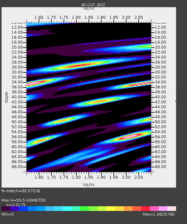
| Estimated Moho Depth: |
55.5 km |
| Estimated Crust Vp/Vs: |
2.02 |
| Assumed Crust Vp: |
6.438 km/s |
| Estimated Crust Vs: |
3.191 km/s |
| Estimated Crust Poisson's Ratio: |
0.34 |
|
| Radial Match: |
88.57036 % |
| Radial Bump: |
400 |
| Transverse Match: |
81.14102 % |
| Transverse Bump: |
400 |
| SOD ConfigId: |
31937991 |
| Insert Time: |
2023-10-21 08:46:47.084 +0000 |
| GWidth: |
2.5 |
| Max Bumps: |
400 |
| Tol: |
0.001 |
|

Signal To Noise
| Channel | StoN | STA | LTA |
| AK:CUT: :BHZ:20231007T08:46:15.580008Z | 13.961288 | 4.893392E-6 | 3.5049717E-7 |
| AK:CUT: :BHN:20231007T08:46:15.580008Z | 3.585046 | 2.0039417E-6 | 5.589724E-7 |
| AK:CUT: :BHE:20231007T08:46:15.580008Z | 6.924131 | 2.356475E-6 | 3.4032792E-7 |
| Arrivals |
| Ps | 9.0 SECOND |
| PpPs | 25 SECOND |
| PsPs/PpSs | 34 SECOND |


