You are here: Home > Network List > TA - USArray Transportable Network (new EarthScope stations) Stations List
> Station Z33A Whitaker Ranch, Olney, TX, USA > Earthquake Result Viewer
Z33A Whitaker Ranch, Olney, TX, USA - Earthquake Result Viewer
| Earthquake location: |
Tonga Islands |
| Earthquake latitude/longitude: |
-15.1/-173.5 |
| Earthquake time(UTC): |
2010/07/25 (206) 03:39:17 GMT |
| Earthquake Depth: |
7.0 km |
| Earthquake Magnitude: |
5.6 MB, 5.7 MS, 5.9 MW, 5.9 MW |
| Earthquake Catalog/Contributor: |
WHDF/NEIC |
|
| Network: |
TA USArray Transportable Network (new EarthScope stations) |
| Station: |
Z33A Whitaker Ranch, Olney, TX, USA |
| Lat/Lon: |
33.29 N/98.76 W |
| Elevation: |
362 m |
|
| Distance: |
85.9 deg |
| Az: |
54.127 deg |
| Baz: |
249.156 deg |
| Ray Param: |
0.044429146 |
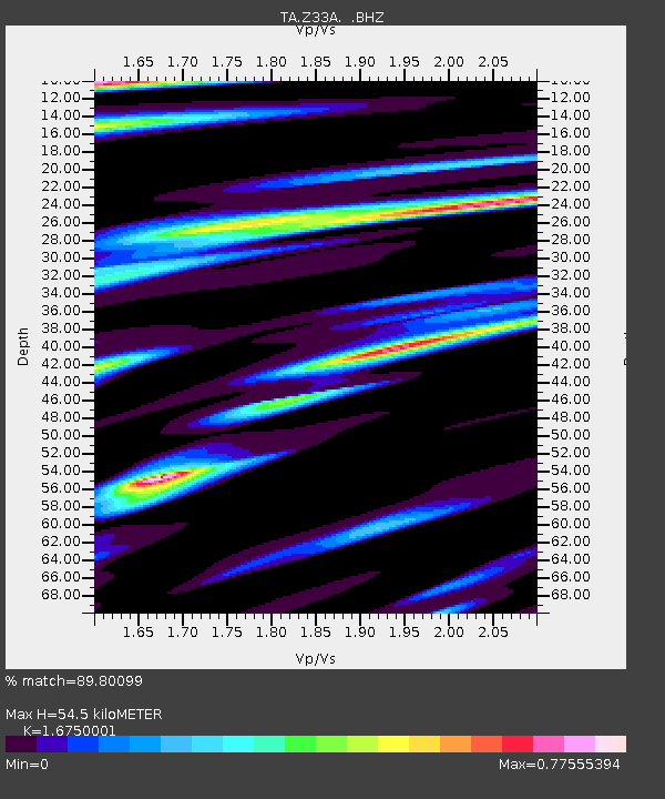
| Estimated Moho Depth: |
54.5 km |
| Estimated Crust Vp/Vs: |
1.68 |
| Assumed Crust Vp: |
6.426 km/s |
| Estimated Crust Vs: |
3.836 km/s |
| Estimated Crust Poisson's Ratio: |
0.22 |
|
| Radial Match: |
89.80099 % |
| Radial Bump: |
357 |
| Transverse Match: |
69.188736 % |
| Transverse Bump: |
400 |
| SOD ConfigId: |
319893 |
| Insert Time: |
2011-01-05 11:10:35.781 +0000 |
| GWidth: |
2.5 |
| Max Bumps: |
400 |
| Tol: |
0.001 |
|
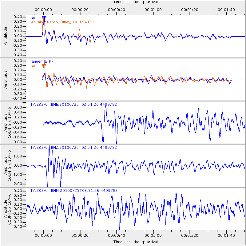
Signal To Noise
| Channel | StoN | STA | LTA |
| TA:Z33A: :BHZ:20100725T03:51:26.449978Z | 18.055511 | 9.729853E-7 | 5.3888545E-8 |
| TA:Z33A: :BHN:20100725T03:51:26.449978Z | 0.6757913 | 4.827018E-8 | 7.1427635E-8 |
| TA:Z33A: :BHE:20100725T03:51:26.449978Z | 7.094035 | 3.7361932E-7 | 5.2666685E-8 |
| Arrivals |
| Ps | 5.9 SECOND |
| PpPs | 22 SECOND |
| PsPs/PpSs | 28 SECOND |


