You are here: Home > Network List > AK - Alaska Regional Network Stations List
> Station M20K Styx River, AK, USA > Earthquake Result Viewer
M20K Styx River, AK, USA - Earthquake Result Viewer
| Earthquake location: |
Eastern New Guinea Reg., P.N.G. |
| Earthquake latitude/longitude: |
-5.6/146.1 |
| Earthquake time(UTC): |
2023/10/07 (280) 08:34:26 GMT |
| Earthquake Depth: |
53 km |
| Earthquake Magnitude: |
6.7 mww |
| Earthquake Catalog/Contributor: |
NEIC PDE/us |
|
| Network: |
AK Alaska Regional Network |
| Station: |
M20K Styx River, AK, USA |
| Lat/Lon: |
61.88 N/153.13 W |
| Elevation: |
1107 m |
|
| Distance: |
81.7 deg |
| Az: |
24.69 deg |
| Baz: |
241.35 deg |
| Ray Param: |
0.04734047 |
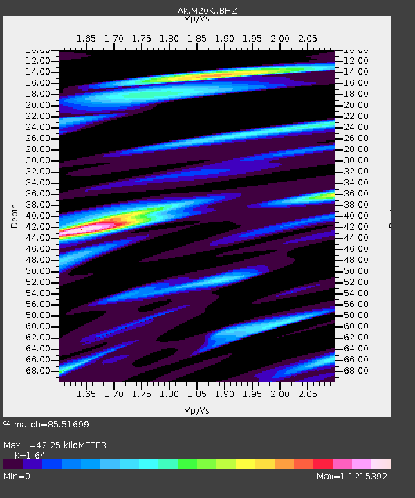
| Estimated Moho Depth: |
42.25 km |
| Estimated Crust Vp/Vs: |
1.64 |
| Assumed Crust Vp: |
6.566 km/s |
| Estimated Crust Vs: |
4.004 km/s |
| Estimated Crust Poisson's Ratio: |
0.20 |
|
| Radial Match: |
85.51699 % |
| Radial Bump: |
400 |
| Transverse Match: |
79.72176 % |
| Transverse Bump: |
400 |
| SOD ConfigId: |
31937991 |
| Insert Time: |
2023-10-21 08:50:12.176 +0000 |
| GWidth: |
2.5 |
| Max Bumps: |
400 |
| Tol: |
0.001 |
|

Signal To Noise
| Channel | StoN | STA | LTA |
| AK:M20K: :BHZ:20231007T08:46:08.119986Z | 24.67094 | 5.761241E-6 | 2.3352337E-7 |
| AK:M20K: :BHN:20231007T08:46:08.119986Z | 5.8640904 | 1.21866E-6 | 2.0781741E-7 |
| AK:M20K: :BHE:20231007T08:46:08.119986Z | 6.8663387 | 1.2157475E-6 | 1.7705905E-7 |
| Arrivals |
| Ps | 4.2 SECOND |
| PpPs | 16 SECOND |
| PsPs/PpSs | 21 SECOND |


