You are here: Home > Network List > TA - USArray Transportable Network (new EarthScope stations) Stations List
> Station 233A Rising Star, TX, USA > Earthquake Result Viewer
233A Rising Star, TX, USA - Earthquake Result Viewer
| Earthquake location: |
Tonga Islands |
| Earthquake latitude/longitude: |
-15.1/-173.5 |
| Earthquake time(UTC): |
2010/07/25 (206) 03:39:17 GMT |
| Earthquake Depth: |
7.0 km |
| Earthquake Magnitude: |
5.6 MB, 5.7 MS, 5.9 MW, 5.9 MW |
| Earthquake Catalog/Contributor: |
WHDF/NEIC |
|
| Network: |
TA USArray Transportable Network (new EarthScope stations) |
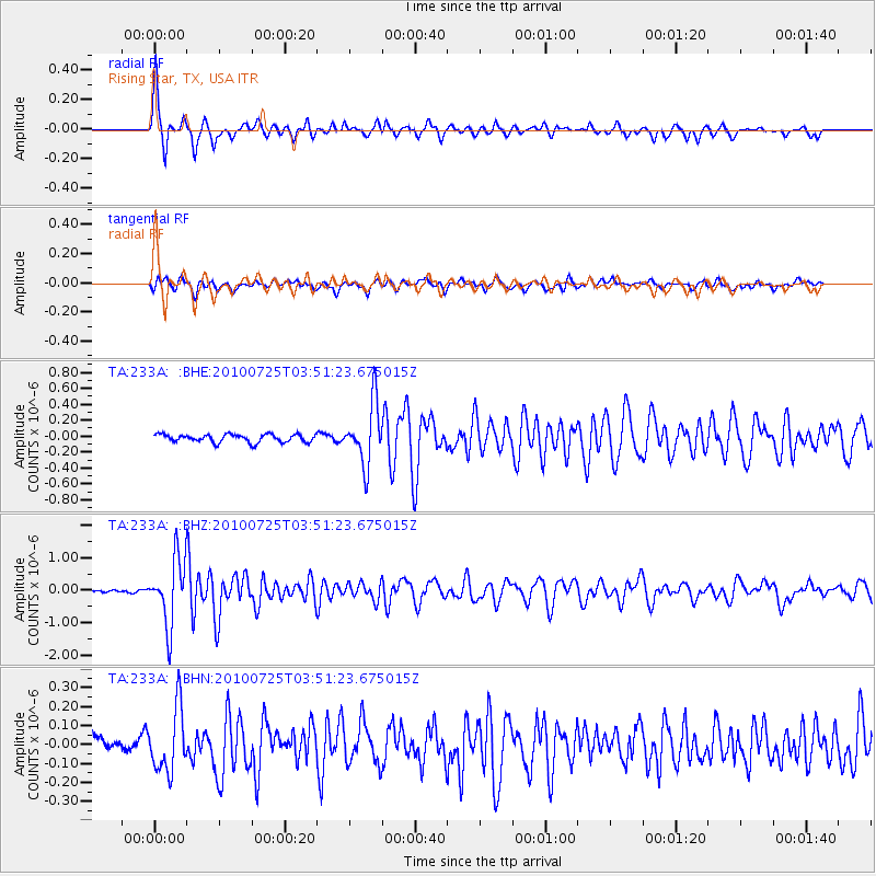
| Station: |
233A Rising Star, TX, USA |
| Lat/Lon: |
32.02 N/98.90 W |
| Elevation: |
539 m |
|
| Distance: |
85.4 deg |
| Az: |
55.272 deg |
| Baz: |
249.171 deg |
| Ray Param: |
0.04482753 |
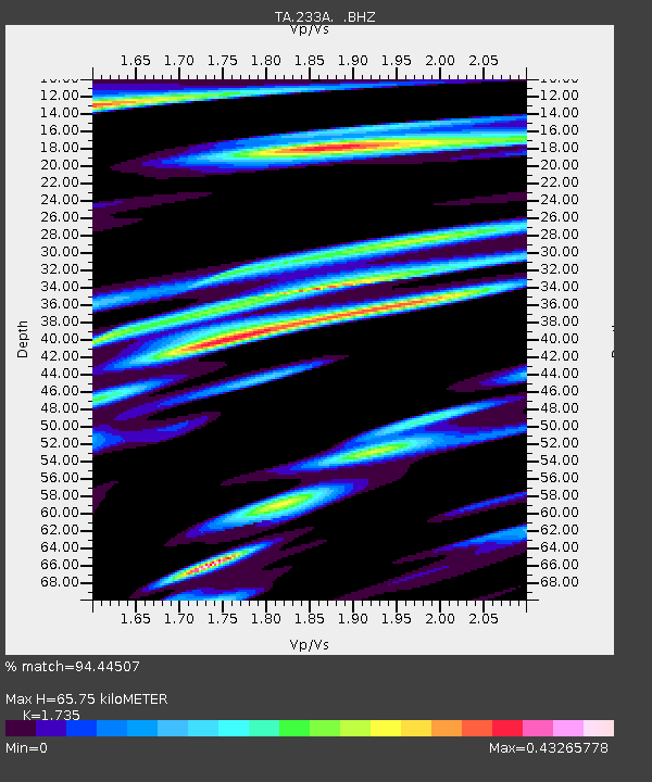
| Estimated Moho Depth: |
65.75 km |
| Estimated Crust Vp/Vs: |
1.74 |
| Assumed Crust Vp: |
6.426 km/s |
| Estimated Crust Vs: |
3.704 km/s |
| Estimated Crust Poisson's Ratio: |
0.25 |
|
| Radial Match: |
94.44507 % |
| Radial Bump: |
281 |
| Transverse Match: |
70.839874 % |
| Transverse Bump: |
400 |
| SOD ConfigId: |
319893 |
| Insert Time: |
2011-01-05 11:12:06.368 +0000 |
| GWidth: |
2.5 |
| Max Bumps: |
400 |
| Tol: |
0.001 |
|
Signal To Noise
| Channel | StoN | STA | LTA |
| TA:233A: :BHZ:20100725T03:51:23.675015Z | 21.758574 | 1.0091354E-6 | 4.6378748E-8 |
| TA:233A: :BHN:20100725T03:51:23.675015Z | 3.4343996 | 1.6634424E-7 | 4.8434735E-8 |
| TA:233A: :BHE:20100725T03:51:23.675015Z | 7.6308255 | 3.786681E-7 | 4.9623477E-8 |
| Arrivals |
| Ps | 7.7 SECOND |
| PpPs | 27 SECOND |
| PsPs/PpSs | 35 SECOND |


