You are here: Home > Network List > TA - USArray Transportable Network (new EarthScope stations) Stations List
> Station 832A Faith Ranch, Carrizo Springs, TX, USA > Earthquake Result Viewer
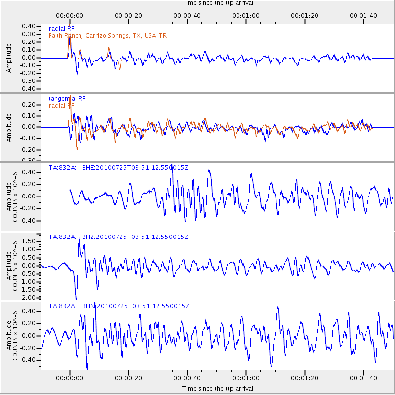
832A Faith Ranch, Carrizo Springs, TX, USA - Earthquake Result Viewer
| Earthquake location: |
Tonga Islands |
| Earthquake latitude/longitude: |
-15.1/-173.5 |
| Earthquake time(UTC): |
2010/07/25 (206) 03:39:17 GMT |
| Earthquake Depth: |
7.0 km |
| Earthquake Magnitude: |
5.6 MB, 5.7 MS, 5.9 MW, 5.9 MW |
| Earthquake Catalog/Contributor: |
WHDF/NEIC |
|
| Network: |
TA USArray Transportable Network (new EarthScope stations) |
| Station: |
832A Faith Ranch, Carrizo Springs, TX, USA |
| Lat/Lon: |
28.28 N/99.97 W |
| Elevation: |
238 m |
|
| Distance: |
83.2 deg |
| Az: |
58.43 deg |
| Baz: |
248.95 deg |
| Ray Param: |
0.046392534 |
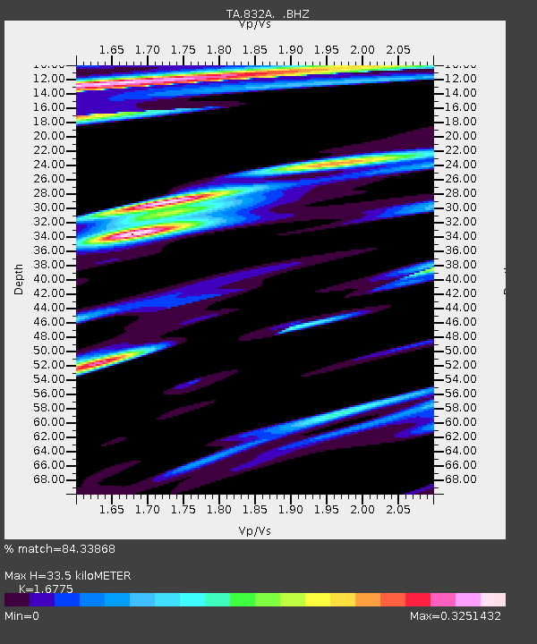
| Estimated Moho Depth: |
33.5 km |
| Estimated Crust Vp/Vs: |
1.68 |
| Assumed Crust Vp: |
6.347 km/s |
| Estimated Crust Vs: |
3.784 km/s |
| Estimated Crust Poisson's Ratio: |
0.22 |
|
| Radial Match: |
84.33868 % |
| Radial Bump: |
379 |
| Transverse Match: |
67.7229 % |
| Transverse Bump: |
400 |
| SOD ConfigId: |
319893 |
| Insert Time: |
2011-01-05 11:12:43.054 +0000 |
| GWidth: |
2.5 |
| Max Bumps: |
400 |
| Tol: |
0.001 |
|
Signal To Noise
| Channel | StoN | STA | LTA |
| TA:832A: :BHZ:20100725T03:51:12.550015Z | 10.641903 | 9.714666E-7 | 9.128693E-8 |
| TA:832A: :BHN:20100725T03:51:12.550015Z | 1.6196684 | 1.6837093E-7 | 1.0395395E-7 |
| TA:832A: :BHE:20100725T03:51:12.550015Z | 2.2341363 | 1.906062E-7 | 8.5315385E-8 |
| Arrivals |
| Ps | 3.7 SECOND |
| PpPs | 14 SECOND |
| PsPs/PpSs | 17 SECOND |


