You are here: Home > Network List > TA - USArray Transportable Network (new EarthScope stations) Stations List
> Station 339A Huntington, TX, USA > Earthquake Result Viewer
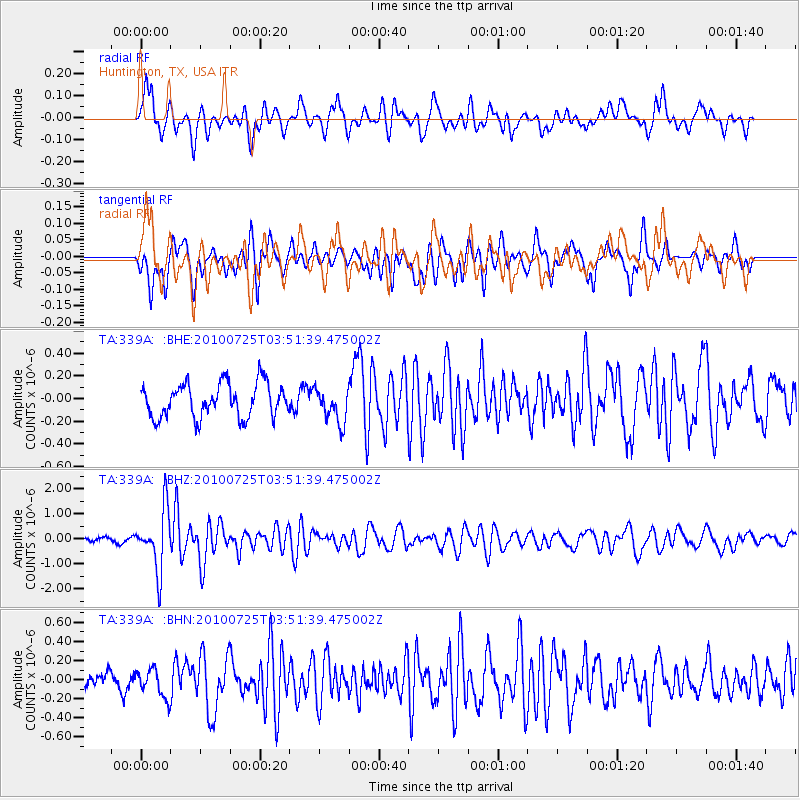
339A Huntington, TX, USA - Earthquake Result Viewer
*The percent match for this event was below the threshold and hence no stack was calculated.
| Earthquake location: |
Tonga Islands |
| Earthquake latitude/longitude: |
-15.1/-173.5 |
| Earthquake time(UTC): |
2010/07/25 (206) 03:39:17 GMT |
| Earthquake Depth: |
7.0 km |
| Earthquake Magnitude: |
5.6 MB, 5.7 MS, 5.9 MW, 5.9 MW |
| Earthquake Catalog/Contributor: |
WHDF/NEIC |
|
| Network: |
TA USArray Transportable Network (new EarthScope stations) |
| Station: |
339A Huntington, TX, USA |
| Lat/Lon: |
31.33 N/94.56 W |
| Elevation: |
82 m |
|
| Distance: |
88.6 deg |
| Az: |
57.162 deg |
| Baz: |
251.541 deg |
| Ray Param: |
$rayparam |
*The percent match for this event was below the threshold and hence was not used in the summary stack. |
|
| Radial Match: |
70.58124 % |
| Radial Bump: |
400 |
| Transverse Match: |
70.20408 % |
| Transverse Bump: |
400 |
| SOD ConfigId: |
319893 |
| Insert Time: |
2011-01-05 11:14:07.275 +0000 |
| GWidth: |
2.5 |
| Max Bumps: |
400 |
| Tol: |
0.001 |
|
Signal To Noise
| Channel | StoN | STA | LTA |
| TA:339A: :BHZ:20100725T03:51:39.475002Z | 11.26051 | 1.1955997E-6 | 1.0617632E-7 |
| TA:339A: :BHN:20100725T03:51:39.475002Z | 1.1498698 | 1.4679053E-7 | 1.2765838E-7 |
| TA:339A: :BHE:20100725T03:51:39.475002Z | 1.0267236 | 1.527811E-7 | 1.4880449E-7 |
| Arrivals |
| Ps | |
| PpPs | |
| PsPs/PpSs | |


