You are here: Home > Network List > TA - USArray Transportable Network (new EarthScope stations) Stations List
> Station 340A Bronson, TX, USA > Earthquake Result Viewer
340A Bronson, TX, USA - Earthquake Result Viewer
| Earthquake location: |
Tonga Islands |
| Earthquake latitude/longitude: |
-15.1/-173.5 |
| Earthquake time(UTC): |
2010/07/25 (206) 03:39:17 GMT |
| Earthquake Depth: |
7.0 km |
| Earthquake Magnitude: |
5.6 MB, 5.7 MS, 5.9 MW, 5.9 MW |
| Earthquake Catalog/Contributor: |
WHDF/NEIC |
|
| Network: |
TA USArray Transportable Network (new EarthScope stations) |
| Station: |
340A Bronson, TX, USA |
| Lat/Lon: |
31.42 N/93.89 W |
| Elevation: |
57 m |
|
| Distance: |
89.2 deg |
| Az: |
57.261 deg |
| Baz: |
251.888 deg |
| Ray Param: |
0.042040743 |
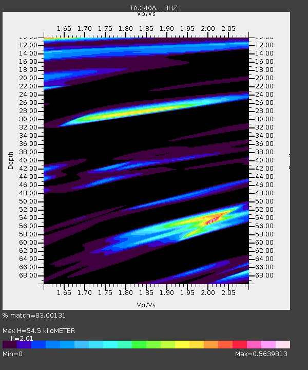
| Estimated Moho Depth: |
54.5 km |
| Estimated Crust Vp/Vs: |
2.01 |
| Assumed Crust Vp: |
6.065 km/s |
| Estimated Crust Vs: |
3.017 km/s |
| Estimated Crust Poisson's Ratio: |
0.34 |
|
| Radial Match: |
83.00131 % |
| Radial Bump: |
400 |
| Transverse Match: |
74.125084 % |
| Transverse Bump: |
276 |
| SOD ConfigId: |
319893 |
| Insert Time: |
2011-01-05 11:14:27.631 +0000 |
| GWidth: |
2.5 |
| Max Bumps: |
400 |
| Tol: |
0.001 |
|

Signal To Noise
| Channel | StoN | STA | LTA |
| TA:340A: :BHZ:20100725T03:51:42.14999Z | 14.073863 | 1.0764762E-6 | 7.6487616E-8 |
| TA:340A: :BHN:20100725T03:51:42.14999Z | 1.1193285 | 1.281456E-7 | 1.1448436E-7 |
| TA:340A: :BHE:20100725T03:51:42.14999Z | 1.1626668 | 1.1674316E-7 | 1.00409814E-7 |
| Arrivals |
| Ps | 9.2 SECOND |
| PpPs | 27 SECOND |
| PsPs/PpSs | 36 SECOND |


